IMAGES TAKEN NEAR TO
Chelwood, BRISTOL, BS39 4NH
Introduction
This page details the photographs taken nearby to BS39 4NH by members of the Geograph project.
The Geograph project started in 2005 with the aim of publishing, organising and preserving representative images for every square kilometre of Great Britain, Ireland and the Isle of Man.

There are currently over 7.5m images from over14,400 individuals and you can help contribute to the project by visiting https://www.geograph.org.uk
Image Map
Images are licensed for reuse under creativecommons.org/licenses/by-sa/2.0
Notes
- Clicking on the map will re-center to the selected point.
- The higher the marker number, the further away the image location is from the centre of the postcode.
Image Listing (13 Images Found)
Images are licensed for reuse under creativecommons.org/licenses/by-sa/2.0
Image
Details
Distance
2
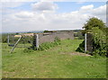
A bridge, but from one field to another
Once this was a bridge over the railway, but since the wholesale axing of the lesser lines the grass has grown quite considerably. Indeed, the ground level now almost fills the tunnel.
Image: © Neil Owen
Taken: 26 Jul 2011
0.08 miles
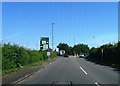
3
2009 : Chelwood House Hotel
Seen from the A368.
Image: © Maurice Pullin
Taken: 15 Mar 2009
0.11 miles
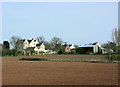
6
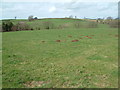
Farmland, Stanton Wick
This is a view from the A368 towards Stanton Wick.
Image: © Stuart Buchan
Taken: 28 Mar 2006
0.20 miles
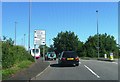
7
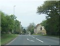
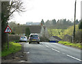
2009 : A368, near the Chelwood Roundabout
A lone motorcyclist approaches the roundabout though all you can see of it from here is the lamp posts.
Coming in on the road from Weston super Mare and Bishop Sutton.
The A368 crosses the A37 here.
Image: © Maurice Pullin
Taken: 15 Mar 2009
0.21 miles
8
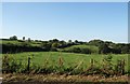
Meadows north of the A368 near Stanton Wick
Image: © David Gearing
Taken: 28 Sep 2011
0.21 miles
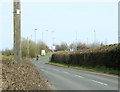
9
2009 : A368 close to Stanton Wick
Facing west and going on to Bishop Sutton. The road here drops into the valley of Salter's Brook.
Image: © Maurice Pullin
Taken: 15 Mar 2009
0.22 miles
10
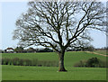
2009 : Oak tree and pasture west of Chelwood
Image: © Maurice Pullin
Taken: 15 Mar 2009
0.22 miles