IMAGES TAKEN NEAR TO
Whitley Batts, BRISTOL, BS39 4NE
Introduction
This page details the photographs taken nearby to Whitley Batts, BS39 4NE by members of the Geograph project.
The Geograph project started in 2005 with the aim of publishing, organising and preserving representative images for every square kilometre of Great Britain, Ireland and the Isle of Man.

There are currently over 7.5m images from over14,400 individuals and you can help contribute to the project by visiting https://www.geograph.org.uk
Image Map (Loading...)


Getting Data...Please wait
Leaflet Map data © OpenStreetMap
Images are licensed for reuse under creativecommons.org/licenses/by-sa/2.0
Notes
- Clicking on the map will re-center to the selected point.
- The higher the marker number, the further away the image location is from the centre of the postcode.
Image Listing (7 Images Found)
Images are licensed for reuse under creativecommons.org/licenses/by-sa/2.0
Image
Details
Distance
1
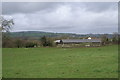
Farm Building
Off the A37 near Pensford
Image: © Adrian and Janet Quantock
Taken: 24 Feb 2007
0.10 miles
2
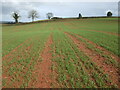
A field off Birchwood Lane
Recently ploughed and planted in the rich soil.
Image: © Neil Owen
Taken: 26 Mar 2021
0.15 miles
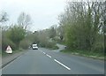
3
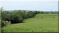
2010 : North at Whitley Batts
Seen from the end of Birchwood Lane. The A37 is over the fence to the left.
Image: © Maurice Pullin
Taken: 16 Aug 2010
0.20 miles
4
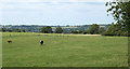
2010 : East of north at Whitley Batts
Looking over a lone-cow pasture.
Image: © Maurice Pullin
Taken: 16 Aug 2010
0.22 miles
6
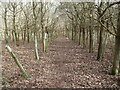
An embryonic woodland
These young trees are becoming a firm feature; a path is neatly defined.
Image: © Neil Owen
Taken: 26 Mar 2021
0.23 miles
7
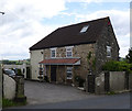
Tollhouse by the A37, Chelwood
Chelwood Tollhouse by the A37, in parish of Publow (Bath and North East Somerset District), Tyreece, Whitley Batts Road, BS39 4NQ.
Bath & North East Somerset HER.
HER number: 62805 https://www.heritagegateway.org.uk/Gateway/Results_Single.aspx?uid=62805&resourceID=1036
Surveyed
Milestone Society National ID: AV.PUB
Image: © Alan Rosevear
Taken: 24 Jun 2013
0.24 miles