IMAGES TAKEN NEAR TO
Cockers Hill, BRISTOL, BS39 4JX
Introduction
This page details the photographs taken nearby to Cockers Hill, BS39 4JX by members of the Geograph project.
The Geograph project started in 2005 with the aim of publishing, organising and preserving representative images for every square kilometre of Great Britain, Ireland and the Isle of Man.

There are currently over 7.5m images from over14,400 individuals and you can help contribute to the project by visiting https://www.geograph.org.uk
Image Map (Loading...)


Getting Data...Please wait
Leaflet Map data © OpenStreetMap
Images are licensed for reuse under creativecommons.org/licenses/by-sa/2.0
Notes
- Clicking on the map will re-center to the selected point.
- The higher the marker number, the further away the image location is from the centre of the postcode.
Image Listing (9 Images Found)
Images are licensed for reuse under creativecommons.org/licenses/by-sa/2.0
Image
Details
Distance
1
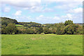
Near Compton Dando
View from a footpath off Cockers Hill.
Image: © Wayland Smith
Taken: 22 Aug 2020
0.09 miles
2
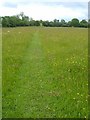
Footpath near Compton Dando
The line of a path across a meadow southwest of the village. There is a maze of footpaths around here; this one leads to Cockers Hill. Another turns right from this point to run alongside the River Chew.
Image: © Derek Harper
Taken: 3 Jun 2005
0.11 miles
3
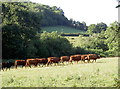
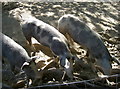
Evening relocation
The balmy summer sun has caused a lot of flies, something these ladies have put up with for too long. En masse, they head for pastures new - and more secluded.
Image: © Neil Owen
Taken: 5 Jul 2017
0.20 miles
4
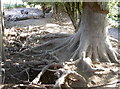
Gnarled and exposed
A rather bare set of roots in this pig field, perhaps not surprising.
Image: © Neil Owen
Taken: 5 Jul 2017
0.20 miles
5
Perfectly camouflaged
If you look carefully, you may be able to make out three pigs in this scene.
Image: © Neil Owen
Taken: 5 Jul 2017
0.20 miles
6
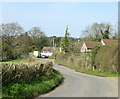
2010 : Heading for Compton Dando on Cockers Hill
More of a slight rise here but it gets steeper further on.
Image: © Maurice Pullin
Taken: 9 Apr 2010
0.21 miles
7
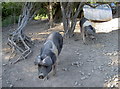
Keeping the weeds down
This little pig pen appears to have been in use for some time, if the exposed tree roots are anything to go by.
Image: © Neil Owen
Taken: 5 Jul 2017
0.21 miles
8
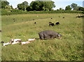
Mum knows the way
A portly mother leads her boisterous brood across the field, despite being populated by black sheep in the main.
Image: © Neil Owen
Taken: 5 Jul 2017
0.23 miles
9
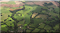
Countryside south of Compton Dando
Rankers Lane winds southwards left of centre, with houses on Cockers Hill on the right. Allens Brake, the linear wood on the left, follows the course (towards the camera) of a tributary of the Chew.
Image: © Derek Harper
Taken: 7 Sep 2018
0.25 miles