IMAGES TAKEN NEAR TO
Parsonage Lane, BRISTOL, BS39 4JD
Introduction
This page details the photographs taken nearby to Parsonage Lane, BS39 4JD by members of the Geograph project.
The Geograph project started in 2005 with the aim of publishing, organising and preserving representative images for every square kilometre of Great Britain, Ireland and the Isle of Man.

There are currently over 7.5m images from over14,400 individuals and you can help contribute to the project by visiting https://www.geograph.org.uk
Image Map (Loading...)


Getting Data...Please wait
Leaflet Map data © OpenStreetMap
Images are licensed for reuse under creativecommons.org/licenses/by-sa/2.0
Notes
- Clicking on the map will re-center to the selected point.
- The higher the marker number, the further away the image location is from the centre of the postcode.
Image Listing (48 Images Found)
Images are licensed for reuse under creativecommons.org/licenses/by-sa/2.0
Image
Details
Distance
1
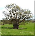
The Publow Oak
One of the oldest oak trees in England, situated in Publow Somerset. More information http://www.monumentaltrees.com/en/gbr/england/somerset/7915_publowfarm/
Image: © Rick Crowley
Taken: 17 Apr 2015
0.09 miles
2
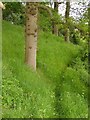
Footpath near Publow
The path along the north side of the River Chew between Pensford and Publow makes its way through a steep grassy patch of woodland.
Image: © Derek Harper
Taken: 3 Jun 2005
0.11 miles
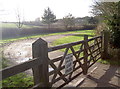
3
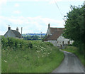
2009 : Approaching Publow Farm
Heading south on Blackrock Lane.
Image: © Maurice Pullin
Taken: 16 Jun 2009
0.18 miles

5
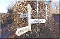
Direction Sign - Signpost in Publow
Pyramid finial - 3 arms; Somerset SCC pyramid by the UC road, in parish of Publow (Bath and North East Somerset District), Parsonage Lane junction with Publow Lane.
Surveyed
Milestone Society National ID: SO_ST6264
Image: © Milestone Society
Taken: Unknown
0.18 miles
6
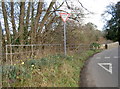
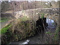
Publow Lane bridge
Some early Daffodils near the bridge. They have been out for a while already after the exceptionally warm winter of '15/16.
Image: © Neil Owen
Taken: 2 Feb 2016
0.18 miles
7
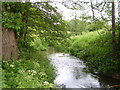
River Chew near Pensford
Looking downstream as the stream makes its way eastwards towards Publow.
Image: © Derek Harper
Taken: 3 Jun 2005
0.19 miles
9
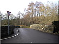
Church car park
The impressive All Saints church lies right on the east bank of the River Chew, but the car park has to reside on the other side of the stone bridge.
Image: © Neil Owen
Taken: 2 Feb 2016
0.19 miles