IMAGES TAKEN NEAR TO
Hunstrete Lane, BRISTOL, BS39 4HU
Introduction
This page details the photographs taken nearby to Hunstrete Lane, BS39 4HU by members of the Geograph project.
The Geograph project started in 2005 with the aim of publishing, organising and preserving representative images for every square kilometre of Great Britain, Ireland and the Isle of Man.

There are currently over 7.5m images from over14,400 individuals and you can help contribute to the project by visiting https://www.geograph.org.uk
Image Map (Loading...)


Getting Data...Please wait
Leaflet Map data © OpenStreetMap
Images are licensed for reuse under creativecommons.org/licenses/by-sa/2.0
Notes
- Clicking on the map will re-center to the selected point.
- The higher the marker number, the further away the image location is from the centre of the postcode.
Image Listing (66 Images Found)
Images are licensed for reuse under creativecommons.org/licenses/by-sa/2.0
Image
Details
Distance
1
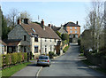
2010 : Main road through Woollard
Controversy in Woollard, thankfully now sorted out.
"For many years delivery lorries and emergency services have had problems finding local properties, because none of the postal addresses had a street name, and the village name of Pensford was also included which was misleading.
To resolve the problem the Council worked with Publow and Compton Dando Parish Councils and as a result street names have now been formally allocated. All properties in Woollard now include a street name and Pensford has been dropped from addresses so that Woollard is a village in its own right. New street nameplates have been installed to make this clear to visitors arriving in the village."
Copied from: http://www.bathnes.gov.uk/BathNES/media/news/2010/March/New+street+names+for+Woollard.htm
Image: © Maurice Pullin
Taken: 9 Apr 2010
0.01 miles
2
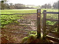
Walk, don't fish
The field carries both the Community Forest path as well as the Two Rivers path - the former going by the River Chew to Publow and the latter up the hill to Lord's Wood.
Image: © Neil Owen
Taken: 2 Feb 2016
0.02 miles
3
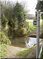
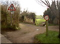
Yes, a very wet byway
Technically open to all traffic, this 'road' is Birchwood Lane and has a width restriction of 3ft 3" imposed on users. During the winter, no-one in their right mind would want to actually drive up this stream, would they? See Image] for the approach.
Image: © Neil Owen
Taken: 2 Feb 2016
0.02 miles
4
Woollard Ford
This is the entrance to a substantial albeit narrow ford at Woollard. A video of the ford can be seen at:
http://youtu.be/0JVK_PHeeD4
Image: © John Walton
Taken: 21 May 2016
0.02 miles
5
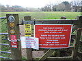
Lots to take in
Much has been made of road networks being plastered with various distracting signs and adverts, but the casual walker may have a similar feeling. The warning for blue-green algae in the water might be the most important.
Image: © Neil Owen
Taken: 19 Dec 2021
0.02 miles
6
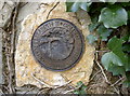
The Packhorse Bridge
A Golden Jubilee plaque has been sited in the wall by the byway in Woollard. Further along the Community Forest Path (CL17/22) is an old stone packhorse bridge (in much need of repair). It is speculated that it was possibly in use by mediaeval times, or certainly by the seventeenth century - possibly in conjunction with the local mills which had been founded.
Image: © Neil Owen
Taken: 2 Feb 2016
0.02 miles
7
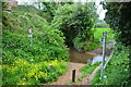
Not only narrow but very wet!
This uncertain little diversion off the main road is Birchwood Lane - a byway open to all traffic. It is not the turn to the left, which is a private car park; the route is actually up the stream further on before the gate. Just bear in mind, though, that this part of it is in fact rather damp under wheel. The width restriction also legally imposes a ban on anything wider than a horse, should anyone try to drive up the stream. See Image] for a better image of where the byway goes.
Image: © Neil Owen
Taken: 2 Feb 2016
0.02 miles
8
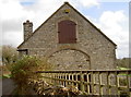
The Tithe Barn
This barn looks to have recent work done on it but no date on the stone.
Image: © Neil Owen
Taken: 2 Feb 2016
0.02 miles
9
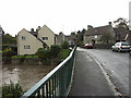
Woollard Bridge and River Chew nearly in flood
Looking West on the 'new' Woollard Bridge over the River Chew, nearly in flood.
The old bridge was destroyed by floods on 10th July 1968. Ye Olde Bell Farm House is on the right. The road continues leftwards towards Publow and Pensford. A diversion to the right goes towards Publow Hill and Keynsham.
Image: © Colin S Pearson
Taken: 6 Nov 2005
0.04 miles
10
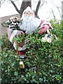
Santa is coming - through the hedge!
An unexpected and unusual form of seasonal decoration, set in a private dwelling's hedge. It even has a solar powered light.
Image: © Neil Owen
Taken: 19 Dec 2021
0.04 miles