IMAGES TAKEN NEAR TO
Peats Hill, BRISTOL, BS39 4HR
Introduction
This page details the photographs taken nearby to Peats Hill, BS39 4HR by members of the Geograph project.
The Geograph project started in 2005 with the aim of publishing, organising and preserving representative images for every square kilometre of Great Britain, Ireland and the Isle of Man.

There are currently over 7.5m images from over14,400 individuals and you can help contribute to the project by visiting https://www.geograph.org.uk
Image Map (Loading...)


Getting Data...Please wait
Leaflet Map data © OpenStreetMap
Images are licensed for reuse under creativecommons.org/licenses/by-sa/2.0
Notes
- Clicking on the map will re-center to the selected point.
- The higher the marker number, the further away the image location is from the centre of the postcode.
Image Listing (45 Images Found)
Images are licensed for reuse under creativecommons.org/licenses/by-sa/2.0
Image
Details
Distance
1
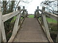
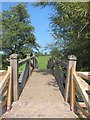
A new footbridge over the Chew
This elegantly built wooden footbridge spans the Chew near Church Farm. It appears to be a fairly recent addition to the area.
Image: © Neil Owen
Taken: 5 Mar 2021
0.08 miles
2
Pipe by Church Farm
It rises up, goes across the River Chew and then drops back into the soil.
Image: © Neil Owen
Taken: 5 Mar 2021
0.08 miles
3
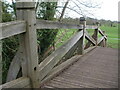
New over The Chew
A new wooden footbridge now allows passage around Church Farm. Perhaps the footpath is now redirected over it and not through the farm as before. Note the traditional appearance using wooden pegs and pins in the construction, with no sign of metal fixtures. Crossing, the bridge gives a pleasing wiggle as befits natural materials.
Image: © Neil Owen
Taken: 5 Mar 2021
0.08 miles
4
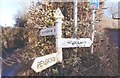
Direction Sign - Signpost in Publow
Pyramid finial - 3 arms; Somerset SCC pyramid by the UC road, in parish of Publow (Bath and North East Somerset District), Parsonage Lane junction with Publow Lane.
Surveyed
Milestone Society National ID: SO_ST6264
Image: © Milestone Society
Taken: Unknown
0.12 miles
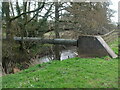
5
Footbridge across the River Chew between Publow and Woolard
Footbridge hardly does it justice-this Rolls Royce of a structure is constructed in solid oak beams with brick paved approaches-must have cost a small fortune. In the middle of a field its significance is obscure.
Image: © Dr Duncan Pepper
Taken: 9 Sep 2014
0.13 miles
6
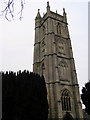
Publow Church
Church of All Saints dates from the 14th century
Image: © Rick Crowley
Taken: 17 Feb 2009
0.13 miles
7
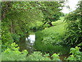
River Chew below Publow
Between Publow and Woollard, the River Chew winds between meadows. Looking downstream.
Image: © Derek Harper
Taken: 3 Jun 2005
0.13 miles
8
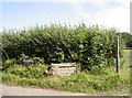
Welcome to Woollard
A now traditional entrance stone, on the outskirts.
Image: © Neil Owen
Taken: 25 Jul 2017
0.14 miles
9
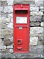
An old letterbox in Publow Lane
A wall-mounted Victorian box, and quite a narrow one at that.
Image: © Neil Owen
Taken: 19 Dec 2021
0.14 miles
10
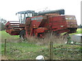
A hibernating harvester?
Looking rather sad and abandoned, this Massey Ferguson combine harvester bears the ignomy of being left in the field to rot. The machine was produced from 1983-86 and had a 5.9l, 6 cylinder Perkins engine that produced 155BHP (116kW).
Image: © Neil Owen
Taken: 5 Mar 2021
0.15 miles