IMAGES TAKEN NEAR TO
Norton Hawkfield, Pensford, BRISTOL, BS39 4HB
Introduction
This page details the photographs taken nearby to BS39 4HB by members of the Geograph project.
The Geograph project started in 2005 with the aim of publishing, organising and preserving representative images for every square kilometre of Great Britain, Ireland and the Isle of Man.

There are currently over 7.5m images from over14,400 individuals and you can help contribute to the project by visiting https://www.geograph.org.uk
Image Map (17 Images)


Getting Data...Please wait
Leaflet Map data © OpenStreetMap
Images are licensed for reuse under creativecommons.org/licenses/by-sa/2.0
Notes
- Clicking on the map will re-center to the selected point.
- The higher the marker number, the further away the image location is from the centre of the postcode.
Image Listing (17 Images Found)
Images are licensed for reuse under creativecommons.org/licenses/by-sa/2.0
Image
Details
Distance
1
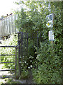
Across Park Farm
A footpath wends its way around the Nortons and through this yard.
Image: © Neil Owen
Taken: 21 May 2015
0.02 miles
2

Direction Sign - Signpost in Norton Hawksfield
Pyramid finial - 3 arms; Somerset SCC pyramid by the UC road, in parish of Norton Malreward (Bath And North East Somerset District), in Norton Hawksfield on the southeast side of the T junction of Northwick Road and Norton Lane.
surveyed
Milestone Society National ID: SO_ST5964
Image: © Milestone Society
Taken: Unknown
0.06 miles
3
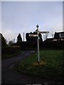
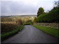
Road junction and signpost, Norton Hawkfield
Image: © John Lord
Taken: 21 Dec 2011
0.07 miles
4
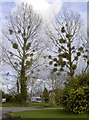
Trees with pom-poms
Some elegant arboreal profiles with plenty of Mistletoe in Park Farm.
Image: © Neil Owen
Taken: 4 Mar 2014
0.07 miles
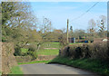
7
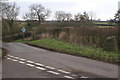
Road Junction by Norton Hawkfield
Image: © Adrian and Janet Quantock
Taken: 11 Mar 2006
0.10 miles
8
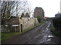
Entrance to Hawkfield Farm, Norton Hawkfield
Image: © John Lord
Taken: 21 Dec 2011
0.10 miles
9
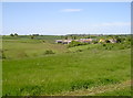
Down to Hawkfield Farm
Looking west over the valley and on to the farm.
Image: © Neil Owen
Taken: 21 May 2015
0.14 miles
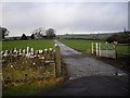
10
2012 : Northwick Road approaching Norton Hawkfield
A hamlet to the south west of Maes Knoll, an ancient camp which dominates this end of Dundry Hill.
Image: © Maurice Pullin
Taken: 25 Mar 2012
0.15 miles