IMAGES TAKEN NEAR TO
Stanton Drew, BRISTOL, BS39 4EW
Introduction
This page details the photographs taken nearby to BS39 4EW by members of the Geograph project.
The Geograph project started in 2005 with the aim of publishing, organising and preserving representative images for every square kilometre of Great Britain, Ireland and the Isle of Man.

There are currently over 7.5m images from over14,400 individuals and you can help contribute to the project by visiting https://www.geograph.org.uk
Image Map (Loading...)


Getting Data...Please wait
Leaflet Map data © OpenStreetMap
Images are licensed for reuse under creativecommons.org/licenses/by-sa/2.0
Notes
- Clicking on the map will re-center to the selected point.
- The higher the marker number, the further away the image location is from the centre of the postcode.
Image Listing (272 Images Found)
Images are licensed for reuse under creativecommons.org/licenses/by-sa/2.0
Image
Details
Distance
1
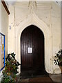
Door, The Church of St Mary the Virgin
The door to the church stands under a pointed arch within a two storey porch.
Image: © Maigheach-gheal
Taken: 27 Dec 2011
0.02 miles
2
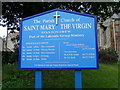
Sign for the Church of St Mary the Virgin
The sign is situated just inside of the church gate.
Image: © Maigheach-gheal
Taken: 27 Dec 2011
0.02 miles
3
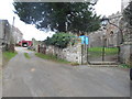
You are approaching
Two entrances one for the aptly named Church Farm the other being for the church of St Mary the virgin.
It is worth noting that the church has opted for a metal arch and lamp rather than a more traditional lytch-gate.
Image: © Anthony Vosper
Taken: 13 Jan 2019
0.02 miles
4
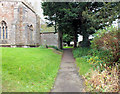
Path to the church
The path leads to the entrance of the church through the north porch below the tower.
Image: © Jonathan Kington
Taken: 27 Dec 2011
0.02 miles
5
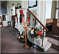
The pulpit
The 19th century stone pulpit, in the south aisle of the church of St Mary the Virgin, has been decorated for Christmas.
Image: © Jonathan Kington
Taken: 27 Dec 2011
0.02 miles
6
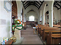
North aisle
The north aisle of the church of St Mary the Virgin is part of the original building with the south aisle, to the right, added during the 19th century. The Norman font can be seen on the left.
Image: © Jonathan Kington
Taken: 27 Dec 2011
0.02 miles
7
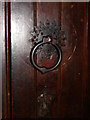
Detail, The Church of St Mary the Virgin
This is the handle to the north door of the church. For a wider view Image
Image: © Maigheach-gheal
Taken: 27 Dec 2011
0.02 miles
8
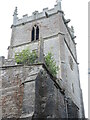
St Mary in bloom
Stanton Drew's old church has some slightly unusual inhabitants clinging to the masonry.
Image: © Neil Owen
Taken: 4 May 2021
0.02 miles
9
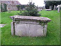
Chest tomb, St Mary the Virgin's Churchyard
The unidentified monument dates from the 18th century and is made of limestone.
Image: © Maigheach-gheal
Taken: 27 Dec 2011
0.02 miles
10
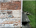
Benchmark on the church
The cut mark can be found on the north-east of the Image, for more information visit http://www.bench-marks.org.uk/bm40658 .
Image: © Jonathan Kington
Taken: 27 Dec 2011
0.02 miles