IMAGES TAKEN NEAR TO
Upper Stanton, Stanton Drew, BRISTOL, BS39 4EQ
Introduction
This page details the photographs taken nearby to BS39 4EQ by members of the Geograph project.
The Geograph project started in 2005 with the aim of publishing, organising and preserving representative images for every square kilometre of Great Britain, Ireland and the Isle of Man.

There are currently over 7.5m images from over14,400 individuals and you can help contribute to the project by visiting https://www.geograph.org.uk
Image Map (48 Images)


Leaflet Map data © OpenStreetMap
Images are licensed for reuse under creativecommons.org/licenses/by-sa/2.0
Notes
- Clicking on the map will re-center to the selected point.
- The higher the marker number, the further away the image location is from the centre of the postcode.
Image Listing (48 Images Found)
Images are licensed for reuse under creativecommons.org/licenses/by-sa/2.0
Image
Details
Distance
1
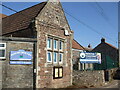
Stanton Drew primary school
The village school, opposite what was the original site in the nineteenth century. A benchmark can be found at the bottom of the wall and office: see Image
Image: © Neil Owen
Taken: 9 Mar 2021
0.04 miles
2
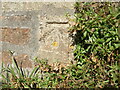
Benchmark on Upper Stanton School
The village primary school has a post-war cutmark; see https://www.bench-marks.org.uk/bm142825 for the entry in the Benchmark Database and Image] for a wider view.
Image: © Neil Owen
Taken: 9 Mar 2021
0.04 miles
3
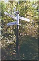
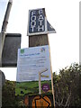
Old Direction Sign - Signpost by Bromley Road, Stanton Drew Parish
Pyramid finial - 3 arms; Somerset SCC pyramid by the UC road, in parish of Stanton Drew (Bath and North East Somerset District), Bromley Road, junction with Upper Stanton, near vicarage.
Surveyed
Milestone Society National ID: SO_ST5962
Image: © Milestone Society
Taken: Unknown
0.11 miles
4
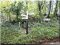
Signpost at the junction of Bromley Road and Upper Stanton
A traditional Somerset signpost, but with the less common black shaft - it's normally grey. At least it has had a fresh coat.
Image: © Neil Owen
Taken: 4 May 2021
0.12 miles
5
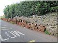
Old Red Sandstone beds neatly dovetailed into a stone wall
Image: © Dr Duncan Pepper
Taken: 28 Jul 2015
0.14 miles
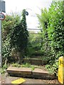
6
Reminder of the Countryside Code
A notice on the footpath post on Bromley Road keeps users informed.
Image: © Neil Owen
Taken: 4 May 2021
0.15 miles
7

To Preston Farm
And also towards the village of Upper Stanton Drew.
Image: © Neil Owen
Taken: 31 Mar 2016
0.16 miles
8

Pasture by The Cove
Gently sloping land south of the ancient standing stones. The River Chew runs not too far from here.
Image: © Neil Owen
Taken: 23 Jan 2015
0.16 miles
9
Start of the Footpath from Stanton Drew to Moorledge
Image: © Dr Duncan Pepper
Taken: 28 Jul 2015
0.17 miles
10
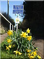
Unsuitable beyond Preston Farm
A sign warns larger loads that the road is about to close in a bit. The embankment is part of that problem, but is brightened by some Spring blooms. These daffs were planted along The Causeway in the Covid year of 2020 by the pupils, staff and villagers of Stanton Drew; there are 500 bulbs, apparently.
Image: © Neil Owen
Taken: 9 Mar 2021
0.18 miles