IMAGES TAKEN NEAR TO
The Orchard, BRISTOL, BS39 4DS
Introduction
This page details the photographs taken nearby to The Orchard, BS39 4DS by members of the Geograph project.
The Geograph project started in 2005 with the aim of publishing, organising and preserving representative images for every square kilometre of Great Britain, Ireland and the Isle of Man.

There are currently over 7.5m images from over14,400 individuals and you can help contribute to the project by visiting https://www.geograph.org.uk
Image Map
Images are licensed for reuse under creativecommons.org/licenses/by-sa/2.0
Notes
- Clicking on the map will re-center to the selected point.
- The higher the marker number, the further away the image location is from the centre of the postcode.
Image Listing (15 Images Found)
Images are licensed for reuse under creativecommons.org/licenses/by-sa/2.0
Image
Details
Distance
1
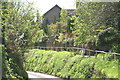
Lane in Upper Stanton Drew
Image: © Adrian and Janet Quantock
Taken: 3 May 2006
0.03 miles
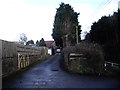
3

2010 : Warning sign at Upper Stanton Drew
It really is, not too good before you get there either.
Image: © Maurice Pullin
Taken: 5 Jul 2010
0.04 miles
4
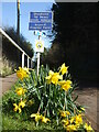
Unsuitable beyond Preston Farm
A sign warns larger loads that the road is about to close in a bit. The embankment is part of that problem, but is brightened by some Spring blooms. These daffs were planted along The Causeway in the Covid year of 2020 by the pupils, staff and villagers of Stanton Drew; there are 500 bulbs, apparently.
Image: © Neil Owen
Taken: 9 Mar 2021
0.05 miles
5

To Preston Farm
And also towards the village of Upper Stanton Drew.
Image: © Neil Owen
Taken: 31 Mar 2016
0.15 miles
6

This way to Bymills Farm
The Two Rivers Path heads off east over the fields surrounding the Chew. Eventually walkers can cross the river at the farm, some half a mile away.
Image: © Neil Owen
Taken: 31 Mar 2016
0.19 miles
7
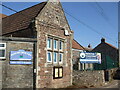
Stanton Drew primary school
The village school, opposite what was the original site in the nineteenth century. A benchmark can be found at the bottom of the wall and office: see Image
Image: © Neil Owen
Taken: 9 Mar 2021
0.20 miles
8
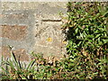
Benchmark on Upper Stanton School
The village primary school has a post-war cutmark; see https://www.bench-marks.org.uk/bm142825 for the entry in the Benchmark Database and Image] for a wider view.
Image: © Neil Owen
Taken: 9 Mar 2021
0.20 miles
9
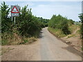
Pensford Lane can be a bit wet at times
Not in this sunny spell, but in wintry times the lane has the potential to become flooded by an issue near the cottage. The Two Rivers Way path crosses the lane here, only to re-cross it a short distance hence.
Image: © Neil Owen
Taken: 17 Jul 2022
0.21 miles