IMAGES TAKEN NEAR TO
Stanton Wick, Pensford, BRISTOL, BS39 4DD
Introduction
This page details the photographs taken nearby to BS39 4DD by members of the Geograph project.
The Geograph project started in 2005 with the aim of publishing, organising and preserving representative images for every square kilometre of Great Britain, Ireland and the Isle of Man.

There are currently over 7.5m images from over14,400 individuals and you can help contribute to the project by visiting https://www.geograph.org.uk
Image Map (Loading...)


Getting Data...Please wait
Leaflet Map data © OpenStreetMap
Images are licensed for reuse under creativecommons.org/licenses/by-sa/2.0
Notes
- Clicking on the map will re-center to the selected point.
- The higher the marker number, the further away the image location is from the centre of the postcode.
Image Listing (11 Images Found)
Images are licensed for reuse under creativecommons.org/licenses/by-sa/2.0
Image
Details
Distance
1
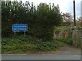
Featherbed Lane
The old lane that runs from Clutton north-west towards Stanton Drew crosses the A368 at this point. Most of the old tarmac has gone and the lane surface is no longer maintained, hence the sign.
Image: © James Ayres
Taken: 25 Oct 2011
0.01 miles
2
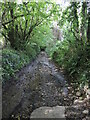
The northern end of Featherbed Lane
A muddy and rough track until it gets to the top of the hill; there it turns into a metalled road as it serves a reservoir.
Image: © Neil Owen
Taken: 17 Sep 2021
0.10 miles
3
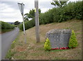
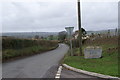
Entrance stone to Stanton Drew
The village boundary is quite some way from the actual settlement.
Image: © Neil Owen
Taken: 31 Jul 2018
0.11 miles
4
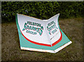
Heavy plant as an entrance sign
A suitably substantial bit of kit is used to mark the entrance to the former Bromley colliery, which now is a small business park.
Image: © Neil Owen
Taken: 31 Jul 2018
0.12 miles
5
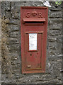
A Georgian letterbox in Stanton Wick
A little faded for a rural 'box. See https://www.geograph.org.uk/photo/5861376 for a wider view.
Image: © Neil Owen
Taken: 31 Jul 2018
0.13 miles
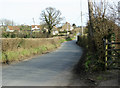
6
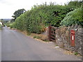
Road linking Stanton Wick and Stanton Drew
Along this modest road is a Georgian letterbox, embedded in the garden wall of a house - see http://www.geograph.org.uk/photo/5861364 for a closer look.
Image: © Neil Owen
Taken: 31 Jul 2018
0.13 miles
8
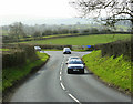
2009 : A368 near Stanton Wick
The road to Stanton Drew leaves to the right at the bottom of the hill.
The A368 leaves the A39 to the west of Marksbury making a useful link between Bath and Weston Super Mare.
Image: © Maurice Pullin
Taken: 15 Mar 2009
0.14 miles
9
2009 : Minor road near Bromley Farm
The A368 is at the top of the hill.
Image: © Maurice Pullin
Taken: 15 Mar 2009
0.15 miles
10
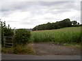
Don't get lost in the maize!
Or whatever the crop is. Footpath towards the old Bromley colliery site takes in a field of tall plants.
Image: © Neil Owen
Taken: 31 Jul 2018
0.21 miles