IMAGES TAKEN NEAR TO
Pensford Lane, BRISTOL, BS39 4BS
Introduction
This page details the photographs taken nearby to Pensford Lane, BS39 4BS by members of the Geograph project.
The Geograph project started in 2005 with the aim of publishing, organising and preserving representative images for every square kilometre of Great Britain, Ireland and the Isle of Man.

There are currently over 7.5m images from over14,400 individuals and you can help contribute to the project by visiting https://www.geograph.org.uk
Image Map
Images are licensed for reuse under creativecommons.org/licenses/by-sa/2.0
Notes
- Clicking on the map will re-center to the selected point.
- The higher the marker number, the further away the image location is from the centre of the postcode.
Image Listing (52 Images Found)
Images are licensed for reuse under creativecommons.org/licenses/by-sa/2.0
Image
Details
Distance
1
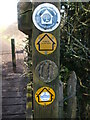
A post full of path markers
The River Chew has a large number of well-frequented footpaths. Various markers of different vintages have served their duty, including a wooden version.
Image: © Neil Owen
Taken: 9 Mar 2021
0.12 miles
2
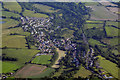
Bath And North East Somerset : Pensford Scenery
Looking down towards the village of Pensford.
Image: © Lewis Clarke
Taken: 18 Jun 2017
0.13 miles
3
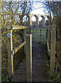
The Two Rivers approaching Pensford viaduct
The Chew was a formidable obstacle to overcome when the railways arrived. Nowadays the valley only echos to motor traffic and the River Chew gently trickles by.
Image: © Neil Owen
Taken: 7 Jan 2018
0.14 miles
4
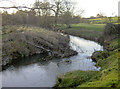
Sign of a busy winter
The recent heavy showers have brought a typical result further down the River Chew: trees are dragged along and banking damaged.
Image: © Neil Owen
Taken: 7 Jan 2018
0.17 miles
5
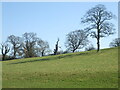
Outstanding in its field
One tree is on its own.
Image: © Neil Owen
Taken: 9 Mar 2021
0.18 miles
6
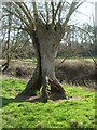
Tripod tree
An unusual tree perched close to the banks of the Chew.
Image: © Neil Owen
Taken: 9 Mar 2021
0.19 miles
7
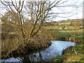
The Chew changes its mind
The River Chew runs indecisively through the Pensford area, although it heads east in general.
Image: © Neil Owen
Taken: 7 Jan 2018
0.19 miles
8
A sign of a former railway
A bit of fencing is propped up by some 'top hat' sections of iron - rail track, being reused.
Image: © Neil Owen
Taken: 9 Mar 2021
0.19 miles
9
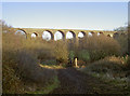
Down to the viaduct
Pensford is dominated by the old railway viaduct, both from the village and the surrounding countryside.
Image: © Neil Owen
Taken: 7 Jan 2018
0.19 miles
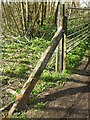
10
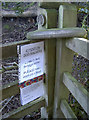
The cows are out for winter
A polite notice on the Two Rivers path inform users that the cattle are not yet in the barns for the winter - unusual for January?
Note the carved roundel on the post - typical of the route here.
Image: © Neil Owen
Taken: 7 Jan 2018
0.19 miles