IMAGES TAKEN NEAR TO
Bredon, BRISTOL, BS37 8TB
Introduction
This page details the photographs taken nearby to Bredon, BS37 8TB by members of the Geograph project.
The Geograph project started in 2005 with the aim of publishing, organising and preserving representative images for every square kilometre of Great Britain, Ireland and the Isle of Man.

There are currently over 7.5m images from over14,400 individuals and you can help contribute to the project by visiting https://www.geograph.org.uk
Image Map (Loading...)


Getting Data...Please wait
Leaflet Map data © OpenStreetMap
Images are licensed for reuse under creativecommons.org/licenses/by-sa/2.0
Notes
- Clicking on the map will re-center to the selected point.
- The higher the marker number, the further away the image location is from the centre of the postcode.
Image Listing (5 Images Found)
Images are licensed for reuse under creativecommons.org/licenses/by-sa/2.0
Image
Details
Distance
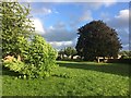
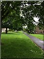
1
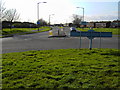
A view west from a roundabout in Yate, Bristol
Yate is a small town north-east of Bristol. This is one of four views from the same roundabout.
Image: © Brian Robert Marshall
Taken: 13 Mar 2007
0.14 miles
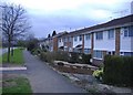
2
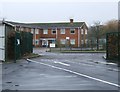
School gateway
The gateway to Culverhill school, taken from the car park, and looking out across Kelston Close towards Wapley Court, a recently closed old people's home.
Image: © Ruth Riddle
Taken: 18 Jan 2012
0.16 miles