IMAGES TAKEN NEAR TO
Kidney Hill, BRISTOL, BS37 8QY
Introduction
This page details the photographs taken nearby to Kidney Hill, BS37 8QY by members of the Geograph project.
The Geograph project started in 2005 with the aim of publishing, organising and preserving representative images for every square kilometre of Great Britain, Ireland and the Isle of Man.

There are currently over 7.5m images from over14,400 individuals and you can help contribute to the project by visiting https://www.geograph.org.uk
Image Map
Images are licensed for reuse under creativecommons.org/licenses/by-sa/2.0
Notes
- Clicking on the map will re-center to the selected point.
- The higher the marker number, the further away the image location is from the centre of the postcode.
Image Listing (4 Images Found)
Images are licensed for reuse under creativecommons.org/licenses/by-sa/2.0
Image
Details
Distance
1
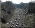
2011 : Mineral line to Westerleigh Rail Head
Formerly part of the main LMS rail line between Bristol, Bath and Birmingham until closed by the Beeching Axe in the 1960's. Became a mineral line linking Westerleigh Rail Head to the main system.
The state of the tracks indicates it is still in use.
Image: © Maurice Pullin
Taken: 20 Mar 2011
0.11 miles
2
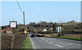
2011 : Coffee Shop and Nursery on Westerleigh Road
Looking east, the red car in the distance is pulling out of the road to Westerleigh.
Image: © Maurice Pullin
Taken: 20 Mar 2011
0.18 miles
3
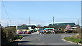
2011 : Garden Centre on Westerleigh Road
With cyclists.
Image: © Maurice Pullin
Taken: 20 Mar 2011
0.21 miles
4
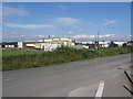
Abattoir, rear view
This is marked as Oakleigh Green Farm on the 1940s OS map.
Image: © William Avery
Taken: 23 Sep 2006
0.25 miles