IMAGES TAKEN NEAR TO
Newman Close, BRISTOL, BS37 8QT
Introduction
This page details the photographs taken nearby to Newman Close, BS37 8QT by members of the Geograph project.
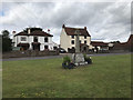
The Geograph project started in 2005 with the aim of publishing, organising and preserving representative images for every square kilometre of Great Britain, Ireland and the Isle of Man.

There are currently over 7.5m images from over14,400 individuals and you can help contribute to the project by visiting https://www.geograph.org.uk
Image Map
Images are licensed for reuse under creativecommons.org/licenses/by-sa/2.0
Notes
- Clicking on the map will re-center to the selected point.
- The higher the marker number, the further away the image location is from the centre of the postcode.
Image Listing (80 Images Found)
Images are licensed for reuse under creativecommons.org/licenses/by-sa/2.0
Image
Details
Distance
2
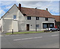
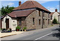
Old Post Office, Westerleigh
The building on the west side of Westerleigh Road has 15th century origins, extended and altered in later centuries. Grade II listed in 2004. Viewed in July 2017, when the Post Office Branch Finder website states that the nearest post office is in Abbotswood Centre, Yate.
Image: © Jaggery
Taken: 20 Jul 2017
0.06 miles
3
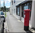
Queen Elizabeth II pillarbox in Westerleigh
Located on the right here, http://www.geograph.org.uk/photo/5477590 at the edge of The Old Post Office, Westerleigh Road.
Image: © Jaggery
Taken: 20 Jul 2017
0.06 miles
4
Westerleigh war memorial and in the background the New Inn
Image: © Steve Fareham
Taken: 4 Nov 2011
0.06 miles
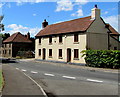
5
Kilminster House, Westerleigh
On the west side of Westerleigh Road, opposite the Church of St James the Great.
Image: © Jaggery
Taken: 20 Jul 2017
0.06 miles
6
Church View Cottages, Westerleigh
Viewed across Westerleigh Road. The church in question is St James the Great. http://www.geograph.org.uk/photo/5477569
Image: © Jaggery
Taken: 20 Jul 2017
0.06 miles
7
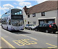
X49 double-decker, Westerleigh Road, Westerleigh
First bus number 37344 is on bus route X49 from Bristol to Yate via Pucklechurch.
Image: © Jaggery
Taken: 20 Jul 2017
0.06 miles
8
Westerleigh Road bus stop and shelter, Westerleigh
On the east side of Westerleigh Road near Homestead Garage https://www.geograph.org.uk/photo/5984925 in South Gloucestershire.
Image: © Jaggery
Taken: 20 Jul 2017
0.07 miles
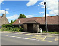
9
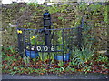
Westerleigh village pump
This example of a village water supply is right outside St James the Great church. The modern ironmongery, dated 2006, is part of a restoration of that date. A plaque states that it was carried out with a grant from Awards For All; work was undertaken by Mark Greenaway, Chew Valley Forge. Westerleigh Village Residents' Association.
Image: © Neil Owen
Taken: 11 Feb 2016
0.07 miles
10
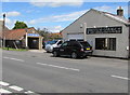
Homestead Garage, Westerleigh
On the east side of Westerleigh Road.
Image: © Jaggery
Taken: 20 Jul 2017
0.07 miles