IMAGES TAKEN NEAR TO
Lower Moor Road, BRISTOL, BS37 7PQ
Introduction
This page details the photographs taken nearby to Lower Moor Road, BS37 7PQ by members of the Geograph project.
The Geograph project started in 2005 with the aim of publishing, organising and preserving representative images for every square kilometre of Great Britain, Ireland and the Isle of Man.

There are currently over 7.5m images from over14,400 individuals and you can help contribute to the project by visiting https://www.geograph.org.uk
Image Map
Images are licensed for reuse under creativecommons.org/licenses/by-sa/2.0
Notes
- Clicking on the map will re-center to the selected point.
- The higher the marker number, the further away the image location is from the centre of the postcode.
Image Listing (9 Images Found)
Images are licensed for reuse under creativecommons.org/licenses/by-sa/2.0
Image
Details
Distance
4
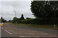
Eastfield Drive
The roundabout at the junction with Leechpool Way in the northern suburbs of Yate.
Image: © Jonathan Billinger
Taken: 23 Mar 2012
0.16 miles
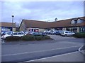
5
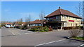
The Brinsham Park
Pub in the suburbs of Yate.
See the facelift this place has received in the five years since Image
Image: © Jonathan Billinger
Taken: 23 Mar 2012
0.17 miles
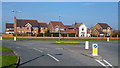
9
Houses on Goose Green Way, Yate
The fronts are on Corbett Close next to the main road.
Image: © David Howard
Taken: 14 Mar 2020
0.25 miles