IMAGES TAKEN NEAR TO
Wickwar Road, BRISTOL, BS37 7BX
Introduction
This page details the photographs taken nearby to Wickwar Road, BS37 7BX by members of the Geograph project.
The Geograph project started in 2005 with the aim of publishing, organising and preserving representative images for every square kilometre of Great Britain, Ireland and the Isle of Man.

There are currently over 7.5m images from over14,400 individuals and you can help contribute to the project by visiting https://www.geograph.org.uk
Image Map
Images are licensed for reuse under creativecommons.org/licenses/by-sa/2.0
Notes
- Clicking on the map will re-center to the selected point.
- The higher the marker number, the further away the image location is from the centre of the postcode.
Image Listing (6 Images Found)
Images are licensed for reuse under creativecommons.org/licenses/by-sa/2.0
Image
Details
Distance
1
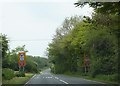
Wickwar Road passing two turnings to Yate Rocks
Looking north along the Wickwar Road, two turnings towards Yate Rocks may be glimpsed on the left, in the foreground and middle distance.
Image: © Ruth Riddle
Taken: 18 May 2012
0.11 miles
2
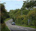
2011 : B4060 to Wickwar, approaching Brinsham Bridge
Serving the Ladden Brook, a tributary of the (Bristol) River Frome.
Image: © Maurice Pullin
Taken: 21 Jun 2011
0.14 miles
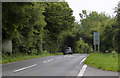
3

Wickwar Road under powerlines
Looking north along the Wickwar Road to where it passes under powerlines.
Image: © Ruth Riddle
Taken: 18 May 2012
0.19 miles
4

2011 : Overgrown quarry sign on the B4060
Near the end of Gravel Hill Road.
Two granite quarries here, one disused to the left of the B4060 - facing south.
The one to the right of the road is still in use hence the warning sign.
This will be a great comfort if a 2 ton lump of rock lands on my C1.
Image: © Maurice Pullin
Taken: 21 Jun 2011
0.19 miles

6
2011 : B4060 south at the end of Gravel Hill Road
Nearly two miles to Chipping Sodbury.
There are granite quarries on either side of the B4060, the one on the left is disused, the one to the right is still active, a sign warns of blasting - or is that "asting"?
Image: © Maurice Pullin
Taken: 21 Jun 2011
0.23 miles