IMAGES TAKEN NEAR TO
Peg Hill, BRISTOL, BS37 7BL
Introduction
This page details the photographs taken nearby to Peg Hill, BS37 7BL by members of the Geograph project.
The Geograph project started in 2005 with the aim of publishing, organising and preserving representative images for every square kilometre of Great Britain, Ireland and the Isle of Man.

There are currently over 7.5m images from over14,400 individuals and you can help contribute to the project by visiting https://www.geograph.org.uk
Image Map
Images are licensed for reuse under creativecommons.org/licenses/by-sa/2.0
Notes
- Clicking on the map will re-center to the selected point.
- The higher the marker number, the further away the image location is from the centre of the postcode.
Image Listing (7 Images Found)
Images are licensed for reuse under creativecommons.org/licenses/by-sa/2.0
Image
Details
Distance
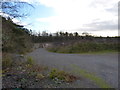
2
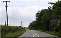
2011 : B4060 Wickwar Road heading north
To Wickwar, three miles to go. Just over one mile out of Chipping Sodbury.
There are stone quarries on both sides of this road screened by trees. One on the right is disused, to the left still active.
Image: © Maurice Pullin
Taken: 21 Jun 2011
0.14 miles
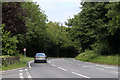
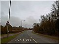
3
Looking south along Wickwar Road
From this point on the Wickwar Road a cycle path towards Chipping Sodbury is provided, separated from the main carriageway by a hedge.
Image: © Ruth Riddle
Taken: 18 May 2012
0.15 miles
4
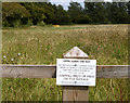
2011 : No Camping no BBQ's no Fires no nothing
Don't much like prohibitory notices but, under these dry conditions especially, highly essential. Good to see it has been observed and that Chipping Sodbury Town Trust are taking care of its assets.
Situated at the north end of The Ridings on the road to Wickwar.
Image: © Maurice Pullin
Taken: 21 Jun 2011
0.15 miles
5
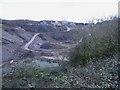
Southfields Quarry
Situated between chipping Sodbury and Wickwar, this quarry (owned by Hanson), is now worked out, but houses the plant, used to process limestone chippings from new workings on the other side of the B4060.
Image: © Roger Cornfoot
Taken: 27 Jan 2007
0.17 miles
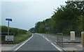
7
2011 : B4060 heading south to Chipping Sodbury
About one and a quarter miles to go.
Image] is behind the trees to the right. There are stone quarries left and right of this road, most are disused.
Image: © Maurice Pullin
Taken: 21 Jun 2011
0.23 miles