IMAGES TAKEN NEAR TO
Merlin Way, BRISTOL, BS37 6XT
Introduction
This page details the photographs taken nearby to Merlin Way, BS37 6XT by members of the Geograph project.
The Geograph project started in 2005 with the aim of publishing, organising and preserving representative images for every square kilometre of Great Britain, Ireland and the Isle of Man.

There are currently over 7.5m images from over14,400 individuals and you can help contribute to the project by visiting https://www.geograph.org.uk
Image Map (Loading...)


Getting Data...Please wait
Leaflet Map data © OpenStreetMap
Images are licensed for reuse under creativecommons.org/licenses/by-sa/2.0
Notes
- Clicking on the map will re-center to the selected point.
- The higher the marker number, the further away the image location is from the centre of the postcode.
Image Listing (10 Images Found)
Images are licensed for reuse under creativecommons.org/licenses/by-sa/2.0
Image
Details
Distance
1
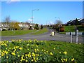
A view east from a roundabout in Yate, Bristol
This road leads to the main road to Chipping Sodbury, a short distance east of Yate. This is one of four views from this roundabout.
Image: © Brian Robert Marshall
Taken: 13 Mar 2007
0.09 miles
2
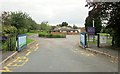
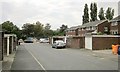
School entrance, Chipping Sodbury
This is the entrance off Finch Road to Raysfield Infants’ School, but in fact the building you can see most clearly is Dodington Parish Hall.
Image: © Derek Harper
Taken: 27 Sep 2014
0.17 miles
3
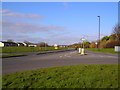
A view north from a roundabout in Yate, Bristol
This road leads to Yate Shopping Centre about a kilometre north of the viewpoint. This is one of four views from the roundabout.
Image: © Brian Robert Marshall
Taken: 13 Mar 2007
0.20 miles
4
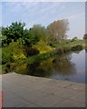
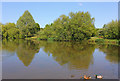
Kingsgate Park. Pond
The reeds near (left banks) the pond
Image: © Alan Thackray
Taken: 7 May 2008
0.21 miles
5

Swan and young
On Kingsgate Pond, Yate
Image: © Charles Drown
Taken: 25 May 2010
0.21 miles
6
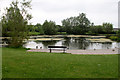
Kingsgate Park
Lake in the park at Chipping Sodbury.
Image: © Wayland Smith
Taken: 7 May 2017
0.21 miles
7
Kingsgate Pond
In Kingsgate Park, Yate, South Gloucestershire
Image: © Charles Drown
Taken: 25 May 2010
0.21 miles
8
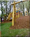
Kingsgate Park. Adventure playground
These playground was built in 2008
Image: © Alan Thackray
Taken: 25 Apr 2008
0.22 miles
10
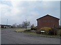
Cul-de-sac, Finch Road
One of a pair of cul-de-sacs on Finch Road in Chipping Sodbury. A footpath across the end links them to Kennedy Way.
Image: © Derek Harper
Taken: 27 Sep 2014
0.23 miles