IMAGES TAKEN NEAR TO
Goldcrest Road, BRISTOL, BS37 6XF
Introduction
This page details the photographs taken nearby to Goldcrest Road, BS37 6XF by members of the Geograph project.
The Geograph project started in 2005 with the aim of publishing, organising and preserving representative images for every square kilometre of Great Britain, Ireland and the Isle of Man.

There are currently over 7.5m images from over14,400 individuals and you can help contribute to the project by visiting https://www.geograph.org.uk
Image Map
Images are licensed for reuse under creativecommons.org/licenses/by-sa/2.0
Notes
- Clicking on the map will re-center to the selected point.
- The higher the marker number, the further away the image location is from the centre of the postcode.
Image Listing (4 Images Found)
Images are licensed for reuse under creativecommons.org/licenses/by-sa/2.0
Image
Details
Distance
1
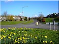
A view east from a roundabout in Yate, Bristol
This road leads to the main road to Chipping Sodbury, a short distance east of Yate. This is one of four views from this roundabout.
Image: © Brian Robert Marshall
Taken: 13 Mar 2007
0.12 miles
2
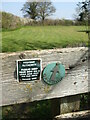
An old pointer
A footpath marker from a previous edition.
Image: © Neil Owen
Taken: 19 Apr 2021
0.17 miles
3
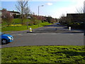
A view south from a roundabout in Yate, Bristol
Yate is a satellite of Bristol. It appears mainly to comprise housing built in the 1960s and later. This is one of four views from the roundabout.
Image: © Brian Robert Marshall
Taken: 13 Mar 2007
0.22 miles
4
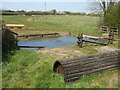
Equestrian test on Dodington Road
A substantial challenge for the eventing.
Image: © Neil Owen
Taken: 19 Apr 2021
0.25 miles