IMAGES TAKEN NEAR TO
Catchpot Lane, BRISTOL, BS37 6SN
Introduction
This page details the photographs taken nearby to Catchpot Lane, BS37 6SN by members of the Geograph project.
The Geograph project started in 2005 with the aim of publishing, organising and preserving representative images for every square kilometre of Great Britain, Ireland and the Isle of Man.

There are currently over 7.5m images from over14,400 individuals and you can help contribute to the project by visiting https://www.geograph.org.uk
Image Map
Images are licensed for reuse under creativecommons.org/licenses/by-sa/2.0
Notes
- Clicking on the map will re-center to the selected point.
- The higher the marker number, the further away the image location is from the centre of the postcode.
Image Listing (6 Images Found)
Images are licensed for reuse under creativecommons.org/licenses/by-sa/2.0
Image
Details
Distance
1
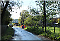
2011 : Entering Dodington village on Catchpot Lane
A tiny place not much more than a hamlet, but not to be underestimated. It has a mention in the Domesday Book.
Image: © Maurice Pullin
Taken: 28 Oct 2011
0.02 miles
3
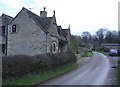
Cottages at Dodington
Former estate dwellings.
Image: © Roger Cornfoot
Taken: 27 Jan 2007
0.10 miles
4
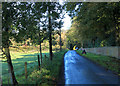
2011 : Minor road leaving Dodington
Heading north on the road to Coomb's End and Old Sodbury.
Image: © Maurice Pullin
Taken: 28 Oct 2011
0.15 miles
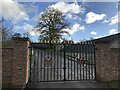
6

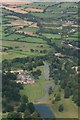
Dodington House, Gloucestershire 1984
Grade 1 listed. Built for the Codrington Family between 1796-1816. Now the home of inventor James Dyson.
Image: © Ray Bird
Taken: Unknown
0.22 miles