IMAGES TAKEN NEAR TO
Little Sodbury, Chipping Sodbury, BRISTOL, BS37 6QY
Introduction
This page details the photographs taken nearby to BS37 6QY by members of the Geograph project.
The Geograph project started in 2005 with the aim of publishing, organising and preserving representative images for every square kilometre of Great Britain, Ireland and the Isle of Man.

There are currently over 7.5m images from over14,400 individuals and you can help contribute to the project by visiting https://www.geograph.org.uk
Image Map
Images are licensed for reuse under creativecommons.org/licenses/by-sa/2.0
Notes
- Clicking on the map will re-center to the selected point.
- The higher the marker number, the further away the image location is from the centre of the postcode.
Image Listing (5 Images Found)
Images are licensed for reuse under creativecommons.org/licenses/by-sa/2.0
Image
Details
Distance
1
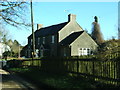
Farm cottages
This pair of cottages lies just to the south of the minor road to Grickstone Farm.
Image: © Ruth Riddle
Taken: 25 Feb 2012
0.01 miles
2
Grickstone Farm
A view looking to the east towards Grickstone Farm.
Image: © Phil Williams
Taken: 6 Jul 2007
0.03 miles
3
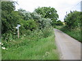
Bridleway and footpath on the lane to Grickstone Farm
A view looking east along the lane to Grickstone Farm, showing a bridleway (left) and footpath (right).
Image: © Phil Williams
Taken: 6 Jul 2007
0.12 miles
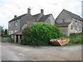
4

Agricultural building
This building lies just to the north of the minor road to Grickstone Farm.
Image: © Ruth Riddle
Taken: 25 Feb 2012
0.20 miles
5
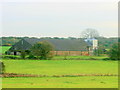
2008 : South east from a layby on the A46
A few fields of pastureland, the barn has a silo on the end, probably for wheat or barley.
Image: © Maurice Pullin
Taken: 17 Oct 2008
0.22 miles