IMAGES TAKEN NEAR TO
Dodington Road, BRISTOL, BS37 6HS
Introduction
This page details the photographs taken nearby to Dodington Road, BS37 6HS by members of the Geograph project.
The Geograph project started in 2005 with the aim of publishing, organising and preserving representative images for every square kilometre of Great Britain, Ireland and the Isle of Man.

There are currently over 7.5m images from over14,400 individuals and you can help contribute to the project by visiting https://www.geograph.org.uk
Image Map
Images are licensed for reuse under creativecommons.org/licenses/by-sa/2.0
Notes
- Clicking on the map will re-center to the selected point.
- The higher the marker number, the further away the image location is from the centre of the postcode.
Image Listing (16 Images Found)
Images are licensed for reuse under creativecommons.org/licenses/by-sa/2.0
Image
Details
Distance
2

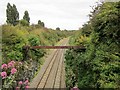
2011 : Main railway line South of Chipping Sodbury
Looking west from the overbridge on Dodington Road.
This way through the Severn Tunnel and on to Cardiff.
Image: © Maurice Pullin
Taken: 3 Oct 2011
0.05 miles
3
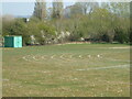
Taking the turns
Lines of the athletics track are already marked out for the pupils. This land used to be a quarry, which was later used for landfill.
Image: © Neil Owen
Taken: 19 Apr 2021
0.05 miles
4
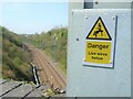
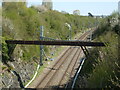
A warning on Lilliput Overbridge
The main rail line from London to Bristol is being converted to use electrical power as well. It has worked up until the approaches to Bristol, where problems are preventing the completion. Currently.
The area is known as Lilliput, after a lost farm of that name on the north side of the line. It is now housing.
Image: © Neil Owen
Taken: 19 Apr 2021
0.07 miles
5
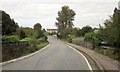
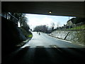
Dodington Road
Crossing the main railway line to enter Chipping Sodbury. The building ahead is part of Chipping Sodbury School.
Image: © Derek Harper
Taken: 27 Sep 2014
0.09 miles
6
Aqueduct across the line, Chipping Sodbury
The aqueduct across the main railway line also appears in Image Mapped as a drain, it's heading towards the Engineering Works on Bowling Road but presumably ends up in the River Frome (which itself crosses the railway on an aqueduct two kilometres further east).
Image: © Derek Harper
Taken: 27 Sep 2014
0.09 miles
7
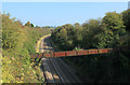
The railway at the south of Chipping Sodbury
Now electrified, with a stout pipeline spanning the cuttings and clearing the passing trains.
Image: © Neil Owen
Taken: 19 Apr 2021
0.09 miles
8
2011 : Main rail line to Paddington
Heading east through Chipping Sodbury, Wootton Bassett, Swindon, and Reading.
A cast iron aqueduct crosses a deep cutting south of Chipping Sodbury.
Image: © Maurice Pullin
Taken: 3 Oct 2011
0.20 miles
10
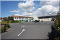
Chipping Sodbury School
A traditional building with a new sports hall.
Image: © Bill Boaden
Taken: 22 Jul 2016
0.22 miles