IMAGES TAKEN NEAR TO
Quarry Road, BRISTOL, BS37 6FN
Introduction
This page details the photographs taken nearby to Quarry Road, BS37 6FN by members of the Geograph project.
The Geograph project started in 2005 with the aim of publishing, organising and preserving representative images for every square kilometre of Great Britain, Ireland and the Isle of Man.

There are currently over 7.5m images from over14,400 individuals and you can help contribute to the project by visiting https://www.geograph.org.uk
Image Map
Images are licensed for reuse under creativecommons.org/licenses/by-sa/2.0
Notes
- Clicking on the map will re-center to the selected point.
- The higher the marker number, the further away the image location is from the centre of the postcode.
Image Listing (130 Images Found)
Images are licensed for reuse under creativecommons.org/licenses/by-sa/2.0
Image
Details
Distance
1
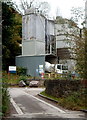
Quarry Road entrance to Hanson site, Chipping Sodbury
Hanson UK produce aggregates (crushed rock, sand and gravel), ready-mixed and precast concrete, asphalt, cement and cement-related materials, bricks and a range of building products. Hanson UK is part of the HeidelbergCement Group, one of the largest building materials manufacturers in the world and the global market leader in aggregates.
Image: © Jaggery
Taken: 10 Oct 2012
0.01 miles
2
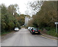
Quarry traffic only, Quarry Road, Chipping Sodbury
The sign on the right is on the corner of Mill Lane. Quarry Road ahead leads to the Hanson site. http://www.geograph.org.uk/photo/3578004
Image: © Jaggery
Taken: 10 Oct 2012
0.01 miles
3

Ridgewood and the quarry, cheek by jowl
Despite the heavy industry right beside it, the Ridgewood trail includes some delicate habitats. The route takes in much of the western half of the narrow, stony ridge to the north of Chipping Sodbury.
Image: © Neil Owen
Taken: 31 May 2012
0.03 miles
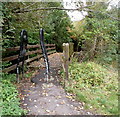
4

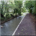
The Frome Valley Walkway
The entrance off Quarry Road into the small meadow running alongside the river, with a barrier to prevent motor vehicles.
Image: © Neil Owen
Taken: 31 May 2012
0.04 miles
5
Bridge to the Frome Valley Walkway, Chipping Sodbury
The wooden footbridge across the River Frome leads to the Frome Valley Walkway.
Viewed from Mill Lane. The River Frome is one of several rivers of that name in the SW of England. Frome is derived from an Old English word meaning fair, fine or brisk, describing the flow of a river.
Image: © Jaggery
Taken: 10 Oct 2012
0.04 miles
6
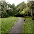
Bench alongside the Frome Valley Walkway, Chipping Sodbury
This parklike section of the walkway is between Brook Street and Mill Lane.
Image: © Jaggery
Taken: 10 Oct 2012
0.05 miles
7
River Frome, Chipping Sodbury
Viewed from Mill Lane. This River Frome is one of several rivers of that name in the SW of England. Frome is derived from an Old English word meaning fair, fine or brisk, describing the flow of a river.
Image: © Jaggery
Taken: 10 Oct 2012
0.07 miles
8
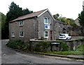
Riverside House, Chipping Sodbury
Located on the corner of Mill Lane and Quarry Road near the River Frome, Riverside House is the premises of FITS Ltd, established in 1991 as a fibre optic company.
Image: © Jaggery
Taken: 10 Oct 2012
0.07 miles
9
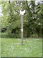
The Kingfisher points the way
A suitably shaped signpost at the eastern end of the Frome Valley Walkway, just off Brook Street.
Image: © Neil Owen
Taken: 31 May 2012
0.07 miles
10
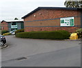
Quarry Road entrance to Bowling Hill Business Park, Chipping Sodbury
The green and white board on the wall shows the location of the offices and business units in the business park.
Image: © Jaggery
Taken: 10 Oct 2012
0.08 miles