IMAGES TAKEN NEAR TO
Love Lane, BRISTOL, BS37 6EX
Introduction
This page details the photographs taken nearby to Love Lane, BS37 6EX by members of the Geograph project.
The Geograph project started in 2005 with the aim of publishing, organising and preserving representative images for every square kilometre of Great Britain, Ireland and the Isle of Man.

There are currently over 7.5m images from over14,400 individuals and you can help contribute to the project by visiting https://www.geograph.org.uk
Image Map
Images are licensed for reuse under creativecommons.org/licenses/by-sa/2.0
Notes
- Clicking on the map will re-center to the selected point.
- The higher the marker number, the further away the image location is from the centre of the postcode.
Image Listing (203 Images Found)
Images are licensed for reuse under creativecommons.org/licenses/by-sa/2.0
Image
Details
Distance
1
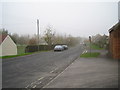
Hounds Road
Hounds Road in Chipping Sodbury, looking North towards St. John's Mead School and the High Street.
Image: © Stephen Bashford
Taken: 23 Nov 2005
0.04 miles
2
Bowling Road electricity substation, Chipping Sodbury
The electricity substation is inside a wooden enclosure above Bowling Road.
Image: © Jaggery
Taken: 18 Jun 2015
0.07 miles
3
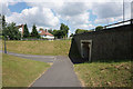
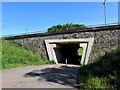
Paths and subway under Kennedy Way
Kennedy Way is a bypass for Chipping Sodbury, but it has been well engineered so that it does not overly affect the surrounding residential areas.
Image: © Bill Boaden
Taken: 22 Jul 2016
0.08 miles
4
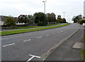
2010 : A432 Chipping Sodbury bypass heading east
Toward Old Sodbury and the junction with the A46.
Image: © Maurice Pullin
Taken: 13 Dec 2010
0.09 miles
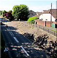
5
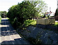
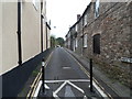
Love Lane underpass, Chipping Sodbury
Love Lane passes under the A432.
Image: © Jaggery
Taken: 18 Jun 2015
0.09 miles
6
Cotswold Road west of Hounds Road, Chipping Sodbury
The A432 Cotswold Road heads west towards Chipping Sodbury School and Bowling Road.
Image: © Jaggery
Taken: 10 Oct 2012
0.09 miles
7
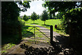
Entrance to Lilliput Park
A park and play area managed by Dodington Parish Council, and grateful for voluntary support in its maintenance.
Image: © Bill Boaden
Taken: 22 Jul 2016
0.12 miles
8
Horseshoe Lane, Chipping Sodbury
Horseshoe Lane heads south away from High Street. Black metal barriers block vehicular access to and from this end. Cars in the distance show that there is access elsewhere.
Image: © Jaggery
Taken: 10 Oct 2012
0.12 miles
9
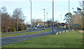
Bowling Road, Chipping Sodbury
Viewed from the A432 bridge. The right turn at the roundabout is into Lilliput Court.
Image: © Jaggery
Taken: 18 Jun 2015
0.12 miles
10
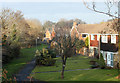
2010 : Grasington Drive, Chipping Sodbury
A fairly new development north of the bypass.
Image: © Maurice Pullin
Taken: 13 Dec 2010
0.12 miles