IMAGES TAKEN NEAR TO
Cotswold Road, BRISTOL, BS37 6DP
Introduction
This page details the photographs taken nearby to Cotswold Road, BS37 6DP by members of the Geograph project.
The Geograph project started in 2005 with the aim of publishing, organising and preserving representative images for every square kilometre of Great Britain, Ireland and the Isle of Man.

There are currently over 7.5m images from over14,400 individuals and you can help contribute to the project by visiting https://www.geograph.org.uk
Image Map
Images are licensed for reuse under creativecommons.org/licenses/by-sa/2.0
Notes
- Clicking on the map will re-center to the selected point.
- The higher the marker number, the further away the image location is from the centre of the postcode.
Image Listing (102 Images Found)
Images are licensed for reuse under creativecommons.org/licenses/by-sa/2.0
Image
Details
Distance
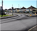
1
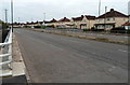
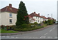
Houses on the south side of Cotswold Road, Chipping Sodbury
Viewed from the edge of a ramp and steps http://www.geograph.org.uk/photo/3582846 leading to an underpass.
Image: © Jaggery
Taken: 10 Oct 2012
0.01 miles
2
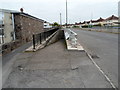
Ramp and steps to a Cotswold Road underpass, Chipping Sodbury
On the north side of the A432 Cotswold Road.
Image: © Jaggery
Taken: 10 Oct 2012
0.05 miles
3
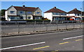
Cotswold Road houses in Chipping Sodbury
View across the A432.
Image: © Jaggery
Taken: 18 Jun 2015
0.06 miles
4
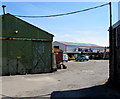
Yard entrance, Chipping Sodbury
From the corner of the A432 Cotswold Road and Hounds Road.
Image: © Jaggery
Taken: 18 Jun 2015
0.07 miles
5
Junction of Hounds Road and the A432 Cotswold Road, Chipping Sodbury
The southern end of Hounds Road is at the dual-carriageway A432 Cotswold Road. No right turn.
Image: © Jaggery
Taken: 18 Jun 2015
0.08 miles
6
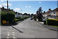
Gaunts Road
A residential street which is a bit older than much of the newer expansion further west.
Image: © Bill Boaden
Taken: 22 Jul 2016
0.08 miles
7
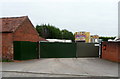
Funfair storage yard, Chipping Sodbury
Viewed from Hounds Lane. In view are a helter skelter and The Hall of Mirrors.
Image: © Jaggery
Taken: 10 Oct 2012
0.09 miles
8
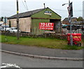
Garage/workshop to let, Chipping Sodbury
The single-storey building is on the corner of Hounds Lane and Cotswold Road.
The red trolley is used to hold letters and parcels for a postal delivery round.
Image: © Jaggery
Taken: 10 Oct 2012
0.09 miles
9
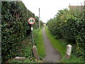
Two Stones Lane, Chipping Sodbury
Viewed from Cotswold Road looking north towards Woodmans Road.
The circular sign with a red edge indicates no cycling.
Image: © Jaggery
Taken: 10 Oct 2012
0.10 miles
10
Woodmans Road, Chipping Sodbury
Viewed from Hounds Road.
Image: © Jaggery
Taken: 10 Oct 2012
0.10 miles