IMAGES TAKEN NEAR TO
Oak Close, BRISTOL, BS37 5TW
Introduction
This page details the photographs taken nearby to Oak Close, BS37 5TW by members of the Geograph project.
The Geograph project started in 2005 with the aim of publishing, organising and preserving representative images for every square kilometre of Great Britain, Ireland and the Isle of Man.

There are currently over 7.5m images from over14,400 individuals and you can help contribute to the project by visiting https://www.geograph.org.uk
Image Map
Images are licensed for reuse under creativecommons.org/licenses/by-sa/2.0
Notes
- Clicking on the map will re-center to the selected point.
- The higher the marker number, the further away the image location is from the centre of the postcode.
Image Listing (7 Images Found)
Images are licensed for reuse under creativecommons.org/licenses/by-sa/2.0
Image
Details
Distance
1
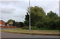
Goose Green Way, Yate
Looking towards Greenways Road
Image: © David Howard
Taken: 23 May 2020
0.06 miles
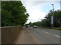
2
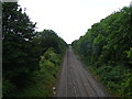
Railway towards Yate
View from the bridge on Goose Green Way.
Image: © JThomas
Taken: 14 Jul 2019
0.11 miles
4
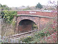
Old bridge over railway
An old bridge over the railway, now closed to vehicular traffic, seen from Goose Green Way near the modern bridge that has been built parallel to the pictured structure.
Image: © Ruth Riddle
Taken: 10 Dec 2011
0.13 miles
5
Goose Green Way
The B4059 towards Iron Acton.
Image: © JThomas
Taken: 14 Jul 2019
0.14 miles

7
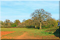
Field near Yate
Near Brimsham Green School.
Image: © Wayland Smith
Taken: 23 Apr 2021
0.16 miles