IMAGES TAKEN NEAR TO
The Glen, BRISTOL, BS37 5PJ
Introduction
This page details the photographs taken nearby to The Glen, BS37 5PJ by members of the Geograph project.
The Geograph project started in 2005 with the aim of publishing, organising and preserving representative images for every square kilometre of Great Britain, Ireland and the Isle of Man.

There are currently over 7.5m images from over14,400 individuals and you can help contribute to the project by visiting https://www.geograph.org.uk
Image Map
Images are licensed for reuse under creativecommons.org/licenses/by-sa/2.0
Notes
- Clicking on the map will re-center to the selected point.
- The higher the marker number, the further away the image location is from the centre of the postcode.
Image Listing (160 Images Found)
Images are licensed for reuse under creativecommons.org/licenses/by-sa/2.0
Image
Details
Distance
1
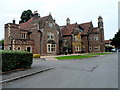
Yate Town Council Offices, Poole Court, Yate
Poole Court was built in the early 1850s as a grand family home, situated in the middle of green fields just off Turnpike Road (now Station Road).
During the First World War, Poole Court was used by the Flying Corps as an Officers Mess after a ministry maintenance base had been established here in Yate. After the war, it remained empty until 1925 when it was bought by George Parnall and Co. and used as offices for the aeroplane industry’s design staff.
In 1932, Augustus and Hedley Newman bought the property and Poole Court reverted to being a home. However, this magnificent building was lost from public sight for many years because of the success of the flourishing electrical machinery business that developed on the site around the house. After Hedley Newman moved out of the house, the building was used as offices.
In 1988, property developers took over the entire site. To prevent the building from being demolished, Yate Town Council entered into negotiations with the developers and the former Northavon District Council, in an effort to both save and obtain the property for the benefit of the community. Following a public consultation, the Town Council agreed to restore the building and use it for community and civic functions, to include the Register Office for marriages. The building was bought by the Town Council for £1!
After alteration and restoration, the building was officially opened in September 1990 by Herr Reiner Wegner, the Burgermeister of Bad Salzdetfurth, Yate's twin town in Germany. The building now houses the Town Council Offices and a number of community rooms, which are let to groups and organisations.
Image: © Jaggery
Taken: 10 Oct 2012
0.06 miles
3

The Glen, Yate
On the north side of Station Road, The Glen leads to School Walk and Tyning Close.
Image: © Jaggery
Taken: 5 Feb 2016
0.09 miles
4

Rivet in the church stonework
A survey rivet, as described in the Benchmark Database: http://www.bench-marks.org.uk/bm40556 , located on the southwest corner of St Mary's church in Yate. Despite standing proud of the stone, it remains in good condition, despite the lichen encroachment. See Image] for a wider view of where to find this easily-overlooked benchmark.
Image: © Neil Owen
Taken: 23 Feb 2012
0.09 miles
5
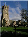
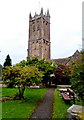
St Mary's, Yate
Although much of Yate is very much twentieth century in age, St Mary's harks back at least to Norman times and possibly to an eighth century church on the same site. The tower is a little younger - the original collapsed in 1546 - and holds a peal of six bells, weighing a total of over three tons. A rivet benchmark can be found on the tower buttress to the left of shot - see Image Also see Image] for a view of the church entrance set against the tower.
Image: © Neil Owen
Taken: 23 Feb 2012
0.09 miles
6
St Mary's church, Yate
Looking up from in front of the entrance to the tower - rebuilt in 1546 or thereabouts after the original came crashing down. Apparently the foundations were inadequate to do the job. See Image] for a longer view.
Image: © Neil Owen
Taken: 23 Feb 2012
0.09 miles
7
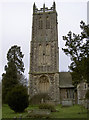
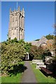
St Mary's church tower, Yate
Viewed from a path through the north side of the churchyard.
Image: © Jaggery
Taken: 10 Oct 2012
0.09 miles
8
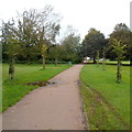
Path to Templar Road, Yate
A path through St Mary's churchyard behind the camera heads towards Templar Road.
Image: © Jaggery
Taken: 10 Oct 2012
0.10 miles
9
St Mary's church, Yate
The tower of St Mary's church in Yate.
Image: © Philip Halling
Taken: 26 Sep 2015
0.10 miles
10
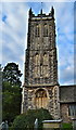
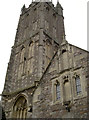
St Mary, Yate
The fine tower of St Mary's, dating from around 1500. It was sensitively restored by W.D. Caroe in 1897-1900.
Image: © Philip Pankhurst
Taken: 20 Oct 2016
0.10 miles