IMAGES TAKEN NEAR TO
Hardwicke, BRISTOL, BS37 4LE
Introduction
This page details the photographs taken nearby to Hardwicke, BS37 4LE by members of the Geograph project.
The Geograph project started in 2005 with the aim of publishing, organising and preserving representative images for every square kilometre of Great Britain, Ireland and the Isle of Man.

There are currently over 7.5m images from over14,400 individuals and you can help contribute to the project by visiting https://www.geograph.org.uk
Image Map
Images are licensed for reuse under creativecommons.org/licenses/by-sa/2.0
Notes
- Clicking on the map will re-center to the selected point.
- The higher the marker number, the further away the image location is from the centre of the postcode.
Image Listing (4 Images Found)
Images are licensed for reuse under creativecommons.org/licenses/by-sa/2.0
Image
Details
Distance
1
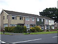
Terraced houses in Yate
This is in Barnwood Road; part of a large 1970's housing estate in Yate. Compare and contrast with Image in the same gridsquare.
Image: © Jonathan Billinger
Taken: 4 Jul 2007
0.21 miles
2
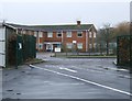
School gateway
The gateway to Culverhill school, taken from the car park, and looking out across Kelston Close towards Wapley Court, a recently closed old people's home.
Image: © Ruth Riddle
Taken: 18 Jan 2012
0.22 miles
3
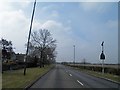
Westerleigh Road, Yate
On the right is the large open space of Westerleigh Common.
Image: © Steve Fareham
Taken: 9 Apr 2013
0.22 miles