IMAGES TAKEN NEAR TO
Sundridge Park, BRISTOL, BS37 4HB
Introduction
This page details the photographs taken nearby to Sundridge Park, BS37 4HB by members of the Geograph project.
The Geograph project started in 2005 with the aim of publishing, organising and preserving representative images for every square kilometre of Great Britain, Ireland and the Isle of Man.

There are currently over 7.5m images from over14,400 individuals and you can help contribute to the project by visiting https://www.geograph.org.uk
Image Map
Images are licensed for reuse under creativecommons.org/licenses/by-sa/2.0
Notes
- Clicking on the map will re-center to the selected point.
- The higher the marker number, the further away the image location is from the centre of the postcode.
Image Listing (20 Images Found)
Images are licensed for reuse under creativecommons.org/licenses/by-sa/2.0
Image
Details
Distance
1
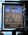
Stanshawes Court name sign, Yate
The sign depicting Stanshawes Court http://www.geograph.org.uk/photo/4531441 is on the corner of Sundridge Park and Stanshawes Court Drive, about 200 metres from the building.
Image: © Jaggery
Taken: 18 Jun 2015
0.09 miles
2
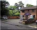
Stanshawes Court Day Nursery, Yate
At 4 Stanshawes Court Drive.
Image: © Jaggery
Taken: 18 Jun 2015
0.09 miles
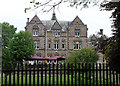
5
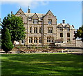
Stanshawes Court, Yate
Former stately home now a restaurant, pub and function venue at the eastern end of Stanshawes Court Drive.
Image: © Jaggery
Taken: 18 Jun 2015
0.14 miles
6
Church behind trees, Yate
St Paul's Catholic Church viewed from Sundridge Park.
Image: © Jaggery
Taken: 18 Jun 2015
0.15 miles
7
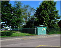
King Edmund School electricity substation, Yate
Viewed across the street named Sundridge Park. The Western Power Distribution electricity substation's identifier is KING EDMUND SCHOOL 01323. Viewed in June 2015 when the school no longer exists.
The old school has been replaced by the 21st century Yate International Academy. http://www.geograph.org.uk/photo/4531483
Image: © Jaggery
Taken: 18 Jun 2015
0.15 miles
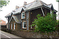
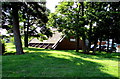
9
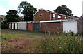
Birkdale lockup garages, Yate
On the NW side of Birkdale houses.
Image: © Jaggery
Taken: 18 Jun 2015
0.17 miles
10
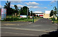
Yate International Academy
Viewed across the street named Sundridge Park. The notes are based on information on the Academy's website.
Specialising in science and sport, Yate International Academy is the first 3-19 all-through Academy in South Gloucestershire. Since becoming an Academy in 2009, £16 million has been invested in replacing the old buildings of King Edmund Community School to transform the learning environment and inspire the students. It now has some of the finest facilities in South Gloucestershire including brand-new classrooms, a 60-seat STEM (Science, Technology, Engineering and Mathematics) theatre and a 240-seat auditorium, photography dark room, all-day canteen, fitness gym, large sports hall, dance studio, four tennis courts and floodlit all-weather pitch.
Image: © Jaggery
Taken: 18 Jun 2015
0.17 miles