IMAGES TAKEN NEAR TO
Normandy Drive, BRISTOL, BS37 4FJ
Introduction
This page details the photographs taken nearby to Normandy Drive, BS37 4FJ by members of the Geograph project.
The Geograph project started in 2005 with the aim of publishing, organising and preserving representative images for every square kilometre of Great Britain, Ireland and the Isle of Man.

There are currently over 7.5m images from over14,400 individuals and you can help contribute to the project by visiting https://www.geograph.org.uk
Image Map (Loading...)


Getting Data...Please wait
Leaflet Map data © OpenStreetMap
Images are licensed for reuse under creativecommons.org/licenses/by-sa/2.0
Notes
- Clicking on the map will re-center to the selected point.
- The higher the marker number, the further away the image location is from the centre of the postcode.
Image Listing (60 Images Found)
Images are licensed for reuse under creativecommons.org/licenses/by-sa/2.0
Image
Details
Distance
1
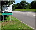
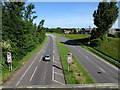
SE boundary of Yate
In South Gloucestershire, the A432 Kennedy Way enters Yate from Chipping Sodbury.
Image: © Jaggery
Taken: 18 Jun 2015
0.04 miles
2
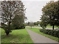
Path, Yate
Beside the A432 Kennedy Way (right).
Image: © Derek Harper
Taken: 27 Sep 2014
0.06 miles
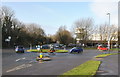
3
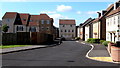
Normandy Drive, Yate
Recently-built housing on the south side of the A432 Kennedy Way.
Image: © Jaggery
Taken: 18 Jun 2015
0.06 miles
4
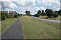
Path by Kennedy Way
Yate has had a recent rapid expansion, and has the appearance of a new town.
Image: © Bill Boaden
Taken: 22 Jul 2016
0.06 miles
5
Towards Yate along Kennedy Way, Chipping Sodbury
Signs on the approach to the end of the dual carriageway show no U-turns for 500 yards.
Image: © Jaggery
Taken: 18 Jun 2015
0.10 miles
6
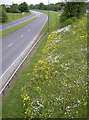
Leave the mowers in the shed!
Council efforts to encourage wild flowers to grow on the embankment has proved colourful. See Image] for a longer view.
Image: © Neil Owen
Taken: 31 May 2012
0.11 miles
7
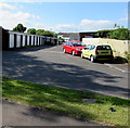
Lockup garages between Estoril and Walton Heath, Yate
In an area of streets named after golf courses.
Image: © Jaggery
Taken: 18 Jun 2015
0.13 miles
8
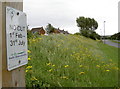
Grass verge or wildlife refuge?
A concerted effort has been made to keep the areas beside the dual carriageway for Mother Nature's benefit. Clearly the halting of regular grass-cutting has allowed a splendid and diverse growth of wild flowers to thrive. See Image] for a signpost.
Image: © Neil Owen
Taken: 31 May 2012
0.13 miles
10
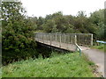
Footbridge over the River Frome, Yate
This footbridge, opposite the Total filling station http://www.geograph.org.uk/photo/3501969 in Link Road, leads to a car park.
The River Frome here, only about 2 metres wide, is more like a stream.
Image: © Jaggery
Taken: 10 Oct 2012
0.15 miles