IMAGES TAKEN NEAR TO
Lyndale Road, BRISTOL, BS37 4DD
Introduction
This page details the photographs taken nearby to Lyndale Road, BS37 4DD by members of the Geograph project.
The Geograph project started in 2005 with the aim of publishing, organising and preserving representative images for every square kilometre of Great Britain, Ireland and the Isle of Man.

There are currently over 7.5m images from over14,400 individuals and you can help contribute to the project by visiting https://www.geograph.org.uk
Image Map (Loading...)


Getting Data...Please wait
Leaflet Map data © OpenStreetMap
Images are licensed for reuse under creativecommons.org/licenses/by-sa/2.0
Notes
- Clicking on the map will re-center to the selected point.
- The higher the marker number, the further away the image location is from the centre of the postcode.
Image Listing (144 Images Found)
Images are licensed for reuse under creativecommons.org/licenses/by-sa/2.0
Image
Details
Distance
1
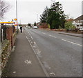
Westerleigh Road, Yate
Looking SW from near the A432 junction.
A nearby sign http://www.geograph.org.uk/photo/5469984 pointing this way shows 2 (miles) to Westerleigh and 4 to Pucklechurch.
Stanshawe Service Station http://www.geograph.org.uk/photo/4913119 is ahead on the left.
Image: © Jaggery
Taken: 5 Feb 2016
0.02 miles
2
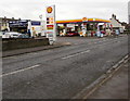
Stanshawe Service Station, Yate
Shell filling station and Spar shop viewed across Westerleigh Road.
Elite Tyre and Autocare is on the left.
Image: © Jaggery
Taken: 5 Feb 2016
0.04 miles
3
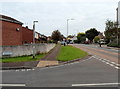
Westerleigh Road, Yate
A view to the NE from the corner of Eggshill Lane.
Image: © Jaggery
Taken: 10 Oct 2012
0.05 miles
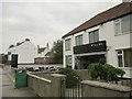
4
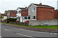
Houses at the southern end of Eggshill Lane, Yate
Viewed from the corner of Westerleigh Road.
Image: © Jaggery
Taken: 10 Oct 2012
0.06 miles
5
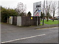
Westerleigh Road electricity substation, Yate
The Western Power Distribution electricity substation is inside a wooden enclosure.
Its identifier is WESTERLEIGH ROAD 8165. A small notice on the enclosure indicates
the presence of SF6 (sulphur hexafluoride, an insulating gas used in high voltage systems).
Image: © Jaggery
Taken: 5 Feb 2016
0.09 miles
6
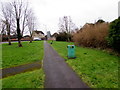
Footpath from Station Road to Westerleigh Road, Yate
Image: © Jaggery
Taken: 5 Feb 2016
0.10 miles
8
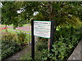
Welcome to Eggshill Lane Play Area, Yate
The welcome sign is in the SW corner of the play area http://www.geograph.org.uk/photo/3369254 The Yate Town Council notice shows
NO DOGS, NO MOTORCYCLES, BICYCLES OR VEHICLES,
NO HORSES NO FIRES NO TENTS NO LITTER NO GOLF
MAXIMUM FINE £500.
Image: © Jaggery
Taken: 10 Oct 2012
0.10 miles
9
Pisces, Station Road, Yate
A fish and chip shop on the A432 opposite a B&Q.
Image: © Derek Harper
Taken: 27 Sep 2014
0.10 miles
10
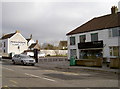
Frying tonight?
A fish and chip shop on Station Road, marking the end of the newer buildings opposite the older to the left.
Image: © Neil Owen
Taken: 23 Feb 2012
0.10 miles