IMAGES TAKEN NEAR TO
Moorland Road, BRISTOL, BS37 4BT
Introduction
This page details the photographs taken nearby to Moorland Road, BS37 4BT by members of the Geograph project.
The Geograph project started in 2005 with the aim of publishing, organising and preserving representative images for every square kilometre of Great Britain, Ireland and the Isle of Man.

There are currently over 7.5m images from over14,400 individuals and you can help contribute to the project by visiting https://www.geograph.org.uk
Image Map
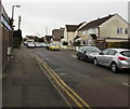
Images are licensed for reuse under creativecommons.org/licenses/by-sa/2.0
Notes
- Clicking on the map will re-center to the selected point.
- The higher the marker number, the further away the image location is from the centre of the postcode.
Image Listing (153 Images Found)
Images are licensed for reuse under creativecommons.org/licenses/by-sa/2.0
Image
Details
Distance
1
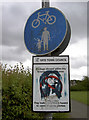
Prohibitive and permissive signs
Perhaps three little birds are allowed?
Image: © Neil Owen
Taken: 31 May 2012
0.05 miles
2
Path from Westerleigh Common to Moorland Road, Yate
From the northern edge of the common.
Image: © Jaggery
Taken: 18 Jun 2015
0.06 miles
3
Run England start marker, Westerleigh Common, Yate
There are two small discs on the wooden post. One shows RUN ENGLAND START.
The other one shows RUN ENGLAND and a red arrow pointing along the direction to follow.
Image: © Jaggery
Taken: 18 Jun 2015
0.07 miles
4
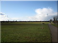
The Common Football Pitches, Yate
Part of Westerleigh Common.
Image: © don cload
Taken: 20 Feb 2010
0.08 miles
5
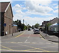
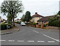
Moorland Road, Yate
On the south side of the A432 Station Road.
A nearby name sign http://www.geograph.org.uk/photo/4860329 shows that Moorland Road leads to Moorpark Avenue and Moordell Close.
Image: © Jaggery
Taken: 5 Feb 2016
0.08 miles
6
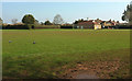
Sunnyside Playing Field
From the gate shown in Image], looking right to the second pavilion, with houses behind it on Moorpark Avenue.
Image: © Derek Harper
Taken: 6 Mar 2020
0.09 miles
7
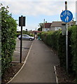
Moorland Road, Yate
South along Moorland Road from Station Road.
The sign on the left shows that Moorland Road is not a through route except for cycles (and walkers).
Image: © Jaggery
Taken: 20 Jul 2017
0.10 miles
8
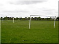
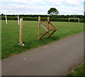
Just the thing for a short game
A football pitch of sorts on what is indeed known as Sunnyside Playing Fields - the goals are about three-quarter size and the pitch is about 30 yards long.
Image: © Neil Owen
Taken: 31 May 2012
0.10 miles
9
Wellstead Avenue, Yate
Viewed across Eggshill Lane.
Image: © Jaggery
Taken: 10 Oct 2012
0.11 miles
10
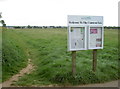
Westerleigh Common
Not only a sign but also a useful notice board. Presumably there are a lot of passers-by to read the notices, as it's in a pretty open site.
Image: © Neil Owen
Taken: 31 May 2012
0.11 miles