IMAGES TAKEN NEAR TO
Thorn Close, BRISTOL, BS37 4BP
Introduction
This page details the photographs taken nearby to Thorn Close, BS37 4BP by members of the Geograph project.
The Geograph project started in 2005 with the aim of publishing, organising and preserving representative images for every square kilometre of Great Britain, Ireland and the Isle of Man.

There are currently over 7.5m images from over14,400 individuals and you can help contribute to the project by visiting https://www.geograph.org.uk
Image Map
Images are licensed for reuse under creativecommons.org/licenses/by-sa/2.0
Notes
- Clicking on the map will re-center to the selected point.
- The higher the marker number, the further away the image location is from the centre of the postcode.
Image Listing (118 Images Found)
Images are licensed for reuse under creativecommons.org/licenses/by-sa/2.0
Image
Details
Distance
1
Wellstead Avenue, Yate
Viewed across Eggshill Lane.
Image: © Jaggery
Taken: 10 Oct 2012
0.05 miles
2
Path through Westerleigh Common, Yate
Along the NE edge of the common.
Image: © Jaggery
Taken: 18 Jun 2015
0.06 miles
3
Houses at the southern end of Eggshill Lane, Yate
Viewed from the corner of Westerleigh Road.
Image: © Jaggery
Taken: 10 Oct 2012
0.07 miles
4
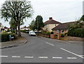
A view SW along Westerleigh Road, Yate
Viewed from near the corner of Eggshill Lane, looking in the direction of Westerleigh Common.
Image: © Jaggery
Taken: 10 Oct 2012
0.07 miles
5
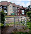
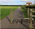
Kissing gate between Westerleigh Common and Westerleigh Road, Yate
In the NE corner of Westerleigh Common. Coopers Court retirement apartments are in the background.
Image: © Jaggery
Taken: 18 Jun 2015
0.08 miles
6
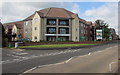
Coopers Court sales office, Yate
On the corner of Stanshawes Drive and Westerleigh Road.
Coopers Court is a McCarthy & Stone development of retirement apartments.
Image: © Jaggery
Taken: 18 Jun 2015
0.09 miles
7
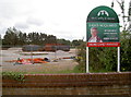
Land acquired
The former H. Cooper and Sons site in Yate has been levelled and now waits to be turned into a residential area. A benchmark lurks on the short wall at the foot of the shot - see Image
Prior to that the area was Hollybrook Brick works in the early twentieth century; the works closed in WWII due to contraction of demand. The large ponds behind it are a clue as to the extraction that took place. Before that it was in fact a prisoner of war camp, holding many Germans taken in the Great War - indeed, the Common is still referred locally as Germans Field.
Image: © Neil Owen
Taken: 31 May 2012
0.09 miles
8
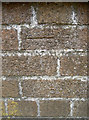
Benchmark on a wall, just!
The wall is about all that is left now of the old Cooper's buildings - see Image] for a view. The benchmark is listed on the Benchmark Database: http://www.bench-marks.org.uk/bm43702
Image: © Neil Owen
Taken: 31 May 2012
0.09 miles
9
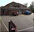
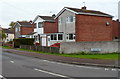
Stanshawes Care Home, Yate
At 11 Stanshawes Drive near the Westerleigh Road junction.
Image: © Jaggery
Taken: 18 Jun 2015
0.10 miles
10
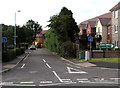
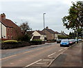
Stanshawes Drive, Yate
Not a through route for motor vehicles. Viewed across Westerleigh Road.
Image: © Jaggery
Taken: 18 Jun 2015
0.11 miles