IMAGES TAKEN NEAR TO
Parson Street, BRISTOL, BS3 5QW
Introduction
This page details the photographs taken nearby to Parson Street, BS3 5QW by members of the Geograph project.
The Geograph project started in 2005 with the aim of publishing, organising and preserving representative images for every square kilometre of Great Britain, Ireland and the Isle of Man.

There are currently over 7.5m images from over14,400 individuals and you can help contribute to the project by visiting https://www.geograph.org.uk
Image Map
Images are licensed for reuse under creativecommons.org/licenses/by-sa/2.0
Notes
- Clicking on the map will re-center to the selected point.
- The higher the marker number, the further away the image location is from the centre of the postcode.
Image Listing (73 Images Found)
Images are licensed for reuse under creativecommons.org/licenses/by-sa/2.0
Image
Details
Distance
1
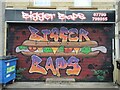
Bigger Baps
A newer paint scheme for the food outlet; the previous one was a tad controversial, featuring a young lady. Previously this shop was called Blackler's.
Image: © Neil Owen
Taken: 10 Jun 2022
0.05 miles
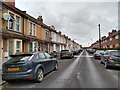
2
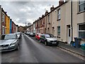
Highbury Road looking Southwest
Highbury Road was built in the late 19th century.
Image: © s
Taken: 1 Mar 2023
0.06 miles
4
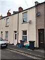
Buildings on Parson Street
At the junction with Hartcliffe Way. On the right is the tastefully-named Big Baps takeaway sandwich shop. In the centre is a convenience store.
Image: © Derek Harper
Taken: 15 Mar 2014
0.06 miles
5
Highbury Road looking Northeast
Highbury Road was built in the late 19th century.
Image: © s
Taken: 1 Mar 2023
0.06 miles
6
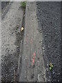
A faint trace of history in a kerbstone
Somermead was the scene of a party. Noting the Queen's recent Platinum Jubilee and the associated street parties that were thrown, this humble road section still has some history in it. During the Silver Jubilee, back in 1977, this road was closed for a party and it was thought a good idea to paint the kerbstones in red, white and blue. The council were not impressed but the red paint remains here after 45 years of the same reign.
Image: © Neil Owen
Taken: 10 Jun 2022
0.08 miles
7

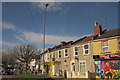
Terrace, Parson Street
With canted bays, between Bedminster Road and Highbury Road.
Image: © Derek Harper
Taken: 15 Mar 2014
0.09 miles
8
Parson Street school
Parson Street primary school at the junction with Bedminster Down road, showing its green domed roof. In the background is the rusty gasholder. During WWII, the school and the gas works had two similar pairs of buildings, but lost one each after bombing raids.
Image: © Neil Owen
Taken: 16 Jan 2009
0.10 miles
9

Parson Street school
Parson Street school was built in 1908, and now has a new reception class block. Note the distinctive green domed structure on the original roof.
Image: © Neil Owen
Taken: 16 Jan 2009
0.10 miles
10
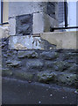
Benchmark at the entrance to Parson Street school
A cutmark (as detailed in the Benchmark Database: http://www.bench-marks.org.uk/bm40586 ) near the entrance gate along Parson Street itself. A lot of the cream coloured stone has had to be repaired but fortunately this one escaped. See Image] for a wider view, and Image] for another on the school in Bedminster Road.
Image: © Neil Owen
Taken: 19 Dec 2011
0.11 miles