IMAGES TAKEN NEAR TO
Novers Hill, BRISTOL, BS3 5QU
Introduction
This page details the photographs taken nearby to Novers Hill, BS3 5QU by members of the Geograph project.
The Geograph project started in 2005 with the aim of publishing, organising and preserving representative images for every square kilometre of Great Britain, Ireland and the Isle of Man.

There are currently over 7.5m images from over14,400 individuals and you can help contribute to the project by visiting https://www.geograph.org.uk
Image Map
Images are licensed for reuse under creativecommons.org/licenses/by-sa/2.0
Notes
- Clicking on the map will re-center to the selected point.
- The higher the marker number, the further away the image location is from the centre of the postcode.
Image Listing (15 Images Found)
Images are licensed for reuse under creativecommons.org/licenses/by-sa/2.0
Image
Details
Distance
1
Ordnance Survey Cut Mark
This OS cut mark can be found on a garage west side of Novers Hill. It marks a point 30.779m above mean sea level.
Image: © Adrian Dust
Taken: 23 Aug 2022
0.02 miles
2
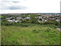
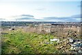
Novers Common, Knowle West
Looking west towards Bedminster Down
Image: © Jez McNeill
Taken: 30 Aug 2011
0.07 miles
3
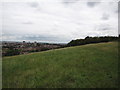
Western Slopes, Knowle West
Looking north towards Bristol city centre. the spire of St Mary recliffe church can be seen between the tower blocks
Image: © Jez McNeill
Taken: 30 Aug 2011
0.15 miles
4
Novers Common from Malago Vale, Bristol
Image: © Anthony O'Neil
Taken: 5 Jul 2010
0.15 miles
5
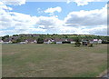
Bristol : Knowle West - Field
A field which has views across the city.
Image: © Lewis Clarke
Taken: 21 Feb 2023
0.16 miles
6
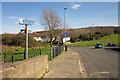
Parson Street becomes Lynton Way
It does so at this junction with Novers Hill (right). A public footpath, BCC/452/20, strikes up the steep hillside to Nover's Common (one has an apostrophe, it seems, and one doesn't) from the junction. Meanwhile, the Malago Greenway leaves on the left, not following a numbered right of way, and on the other side of the stream from the path shown in Image
Image: © Derek Harper
Taken: 15 Mar 2014
0.16 miles
7
Knowle West Health Park
Walk-in health centre on the site of the former Merrywood Girls school, Knowle West, Bristol
Image: © Jez McNeill
Taken: 26 Aug 2011
0.16 miles
8
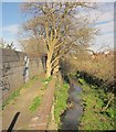
The Malago
Looking downstream from Parson Street. Running along the left side of the stream is footpath BCC/440/10.
Image: © Derek Harper
Taken: 15 Mar 2014
0.18 miles
9
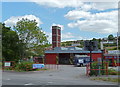
Bedminster Fire Station
Novers Hill is seen in the background.
Image: © Anthony O'Neil
Taken: 5 Jul 2010
0.19 miles
10
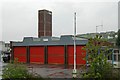
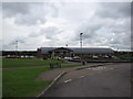
Bedminster Fire Station
Bedminster Fire Station, Hartcliffe Way, Bristol is station number 15 of Avon Fire & Rescue Service. It replaced the previous station in Bond Street Image
Image: © Kevin Hale
Taken: 8 May 2006
0.21 miles