IMAGES TAKEN NEAR TO
Hall Street, BRISTOL, BS3 5PW
Introduction
This page details the photographs taken nearby to Hall Street, BS3 5PW by members of the Geograph project.
The Geograph project started in 2005 with the aim of publishing, organising and preserving representative images for every square kilometre of Great Britain, Ireland and the Isle of Man.

There are currently over 7.5m images from over14,400 individuals and you can help contribute to the project by visiting https://www.geograph.org.uk
Image Map
Images are licensed for reuse under creativecommons.org/licenses/by-sa/2.0
Notes
- Clicking on the map will re-center to the selected point.
- The higher the marker number, the further away the image location is from the centre of the postcode.
Image Listing (171 Images Found)
Images are licensed for reuse under creativecommons.org/licenses/by-sa/2.0
Image
Details
Distance
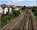
1
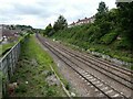
Houses on the tracks
This section of rail just outside Parson Street station has changed in the recent years. Where the new houses of Honeywick Close back onto the lines, there used to be a large number of sidings either side of WWII. Going back further and the G.W.R. main line was only two tracks.
Image: © Neil Owen
Taken: 17 Feb 2022
0.04 miles
2
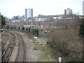
Main line near Parson Street
From across the tracks from Image], again with Polden House and Holroyd House on Windmill Hill in the distance. The houses on the left are on Brighton Crescent. I wonder what all the stuff by the railway line is for?
Image: © Derek Harper
Taken: 15 Mar 2014
0.05 miles
3

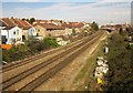
Main line near Parson Street
Seen from Parson Street the road (part of a gyratory on the A38), and looking away from Parson Street the railway station. The distant tower blocks are Polden House and Holroyd House, on Windmill Hill. See also Image
Image: © Derek Harper
Taken: 15 Mar 2014
0.05 miles
4
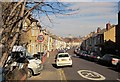
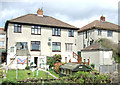
Hall Street, Bedminster
From its junction with Parson Street. On the horizon are the tower blocks visible in Image
Image: © Derek Harper
Taken: 15 Mar 2014
0.05 miles
6
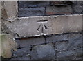
Benchmark on the school wall
One of two benchmarks on Parson Street primary school. See Image] for a wider view of this one and Image] for the one on Parson Street itself. Also see http://www.bench-marks.org.uk/bm23472 for the Benchmark Database, where both are listed.
Image: © Neil Owen
Taken: 19 Dec 2011
0.06 miles
7

Parson Street school
As seen from Bedminster Road. Formerly a storage area, the block behind the wall is now a small swimming pool, and the open ground to the left is a car park. A cut benchmark can be seen on the outside of the wall: Image
Image: © Neil Owen
Taken: 19 Dec 2011
0.06 miles
8
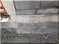
Ordnance Survey Cut Mark
This OS cut mark can be found on the school building SE side of Bedminster Road. It marks a point 13.926m above mean sea level.
Image: © Adrian Dust
Taken: 23 Aug 2022
0.06 miles
9
Railway from Parson Street towards Bedminster, Bristol
Viewed from the A38 Parson Street bridge looking in the direction of Bedminster station.
Parson Street station is behind the camera.
Image: © Jaggery
Taken: 5 Sep 2018
0.06 miles