IMAGES TAKEN NEAR TO
Lynton Road, BRISTOL, BS3 5LT
Introduction
This page details the photographs taken nearby to Lynton Road, BS3 5LT by members of the Geograph project.
The Geograph project started in 2005 with the aim of publishing, organising and preserving representative images for every square kilometre of Great Britain, Ireland and the Isle of Man.

There are currently over 7.5m images from over14,400 individuals and you can help contribute to the project by visiting https://www.geograph.org.uk
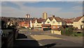
Image Map
Images are licensed for reuse under creativecommons.org/licenses/by-sa/2.0
Notes
- Clicking on the map will re-center to the selected point.
- The higher the marker number, the further away the image location is from the centre of the postcode.
Image Listing (41 Images Found)
Images are licensed for reuse under creativecommons.org/licenses/by-sa/2.0
Image
Details
Distance
1
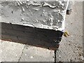
Ordnance Survey Cut Mark
This OS cut mark can be found on No92 Marksbury Road. It marks a point 13.481m above mean sea level.
Image: © Adrian Dust
Taken: 23 Aug 2022
0.06 miles
2
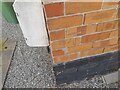
Ordnance Survey Cut Mark
This OS cut mark can be found on No131 Marksbury Road. It marks a point 12.811m above mean sea level.
Image: © Adrian Dust
Taken: 23 Aug 2022
0.07 miles
3
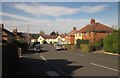
Dawlish Road, Bristol
From Lynton Road. An estate of Devon place-names.
Image: © Derek Harper
Taken: 15 Mar 2014
0.07 miles

5
Broad Plain's main pitch
The rugby club plays here. In the past it was the home of Bristol South End football club (later Bristol City), and a grandstand used to be right in the middle of the current playing field. Later it became a hockey pitch used by the D.R.G. club.
With the area a candidate for development, the scheme to build several townhouses and help the rugby club was agreed, giving the ground some sort of surrounding.
Image: © Neil Owen
Taken: 22 Feb 2022
0.14 miles
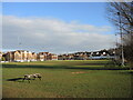
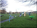
6
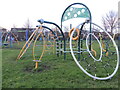
Marksbury Road Playground
In the past the open space was used as landfill for a time. Now the playing fields also offer some varied play equipment.
Image: © Neil Owen
Taken: 11 Dec 2023
0.15 miles
7
Play equipment in Marksbury Road playing fields
Keeping the little ones busy for a while.
Image: © Neil Owen
Taken: 11 Dec 2023
0.15 miles
8
Brixham Road, Bristol
At the crossroad with Lynton Road and Haldon Close.
Image: © Derek Harper
Taken: 15 Mar 2014
0.16 miles
9
Broad Plain R.F.C. clubhouse
The local rugby club has a magnificent modern clubhouse here off St John's Lane. In the late 1800s, Bristol South End football club (later known as Bristol City F.C.) played here until 1904. The ground was given over to other clubs of various sports before the rugby club came here, along with a housing development. Part of the car park here used to be a bowling green, for example.
Image: © Neil Owen
Taken: 22 Feb 2022
0.16 miles
10
Littleton Road, Bristol
Littleton Road is on the far side of this crossroads, seen from Lynton Road. Crossing it is Marksbury Road. The blocks of flats are Polden House and Holroyd House, both in Image
Image: © Derek Harper
Taken: 15 Mar 2014
0.18 miles