IMAGES TAKEN NEAR TO
Glyn Vale, BRISTOL, BS3 5JE
Introduction
This page details the photographs taken nearby to Glyn Vale, BS3 5JE by members of the Geograph project.
The Geograph project started in 2005 with the aim of publishing, organising and preserving representative images for every square kilometre of Great Britain, Ireland and the Isle of Man.

There are currently over 7.5m images from over14,400 individuals and you can help contribute to the project by visiting https://www.geograph.org.uk
Image Map
Images are licensed for reuse under creativecommons.org/licenses/by-sa/2.0
Notes
- Clicking on the map will re-center to the selected point.
- The higher the marker number, the further away the image location is from the centre of the postcode.
Image Listing (18 Images Found)
Images are licensed for reuse under creativecommons.org/licenses/by-sa/2.0
Image
Details
Distance
1
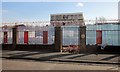
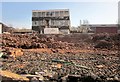
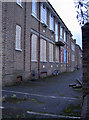
Former City of Bristol College site, Bedminster
And before that, Marksbury Road School (see http://www.geograph.org.uk/search.php?i=48673760 ). All that remains is one small central block. A new primary school Oasis Academy Marksbury Road, is due to be built here, opening in 2015.
Image: © Derek Harper
Taken: 15 Mar 2014
0.20 miles
2
Former City of Bristol College site, Bedminster
A view through the security fence shown in Image A local community organisation had plans for self-build housing, a health centre, a Steiner school, and a range of community, art and recreation facilities on the site, but were disappointed http://www.bbc.co.uk/news/uk-england-bristol-19297387 .
Image: © Derek Harper
Taken: 15 Mar 2014
0.20 miles
3
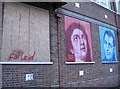
School report?
The art workshop that took over a part of the old Marksbury Road college has tried to bring a little colour to the boarded up windows. Having served many generations of pupils, this college now faced an uncertain future. See Image] for a view along the heavily-defended railings, and Image] for a benchmark.
Image: © Neil Owen
Taken: 29 Dec 2011
0.20 miles
4
Littleton Road, Bristol
Littleton Road is on the far side of this crossroads, seen from Lynton Road. Crossing it is Marksbury Road. The blocks of flats are Polden House and Holroyd House, both in Image
Image: © Derek Harper
Taken: 15 Mar 2014
0.20 miles
5
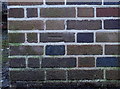
Ordnance Survey Cut Mark
This OS cut mark can be found on No92 Marksbury Road. It marks a point 13.481m above mean sea level.
Image: © Adrian Dust
Taken: 23 Aug 2022
0.20 miles
6
Marksbury Road - closed
School's out! After getting on for a century of education at secondary and further levels, the school has finally closed. There have been a few small ventures to try to keep it going in some form or other, but the future for this old building is unclear. An art facility has attempted to brighten up the boarded up windows - see Image Also a benchmark is still in evidence on the nearer corner - Image
Image: © Neil Owen
Taken: 29 Dec 2011
0.20 miles
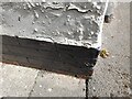
7
Benchmark on Marksbury Road School
A cutmark (as described in the Benchmark Database: http://www.bench-marks.org.uk/bm40665 ) on the corner of what was previously the old school. It has been educating pupils for over seventy years and in its later life the school became a further education college. However, a new college has been built in the Hengrove Park development area (see Colin Bews' image Image]) and this has brought about the closure at Marksbury Road in 2010.
See Image] for a slightly wider view.
Image: © Neil Owen
Taken: 29 Dec 2011
0.21 miles
8
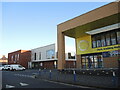
Oasis Academy, Marksbury Road
A new school, opened in 2015, on the site of the old senior school. Beyond is the new surgery, again a new development.
Image: © Neil Owen
Taken: 22 Feb 2022
0.21 miles
9
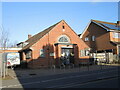
Jubilee Hall and houses, Wedmore Vale
The hall is next door to Image Just up Wedmore Vale is the crossroads with Wingfield Road / Glyn Vale.
Image: © Derek Harper
Taken: 15 Mar 2014
0.23 miles
10
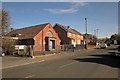
The Jubilee Hall
As this part of Wedmore Vale was being developed, provision for youth activities was given a home in the Jubilee Hall. Not much is known about the early history of the property, but it is believed to have been constructed around 1920 and was presented to the City in 1939 by the Clifton High School for Girls. Later taken on by the local council, it was about to be disposed of but a local group were accepted to use it as a boxing gym. 'Skemer's Gym' has a lease which started in 2019 and they have been successful in extending it recently.
Image: © Neil Owen
Taken: 22 Feb 2022
0.24 miles