IMAGES TAKEN NEAR TO
Beckington Walk, BRISTOL, BS3 5EA
Introduction
This page details the photographs taken nearby to Beckington Walk, BS3 5EA by members of the Geograph project.
The Geograph project started in 2005 with the aim of publishing, organising and preserving representative images for every square kilometre of Great Britain, Ireland and the Isle of Man.

There are currently over 7.5m images from over14,400 individuals and you can help contribute to the project by visiting https://www.geograph.org.uk
Image Map
Images are licensed for reuse under creativecommons.org/licenses/by-sa/2.0
Notes
- Clicking on the map will re-center to the selected point.
- The higher the marker number, the further away the image location is from the centre of the postcode.
Image Listing (56 Images Found)
Images are licensed for reuse under creativecommons.org/licenses/by-sa/2.0
Image
Details
Distance
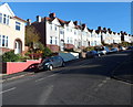
1
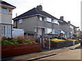
When Satan dropped by for a visit
This unassuming suburban road in south Bristol doesn't give much of a clue about its past. It looks pretty much like a typical inter-war development, and so it remains.
However, on 3/4 January, 1941, it was on the end of a raid by the Luftwaffe - a raid that was thought to have been intended for the aircraft factories of Filton, miles to the north. Among the many incendiaries and smaller H.E. bombs dropped about here, there was an exceptional ordnance which landed right on the pavement in front of the two houses. It was an 1800kg (4000lb) bomb, one of very few of that size ever seen in England. The bomb drove down into the ground to a depth of nearly 9m (30') but fortunately failed to detonate!
With that being the case, it might seem obvious that the area was cleared and bomb disposal teams immediately summoned to deal with it. Strangely, this is not what happened. Indeed, 'Satan' remained in situ for over two years, until Royal Engineer experts dug it out with shovels and a crude chain system on 14th April, 1943! They did ensure the local primary school was evacuated to the park, just in case, allowing a day out of the classrooms.
Having exhumed the weapon and defused it, Satan was taken away and made safe. It eventually was paraded in the Victory celebrations in London in 1945.
The Satan was the heaviest bomb dropped on Britain during the war. See https://www.flickr.com/photos/brizzlebornandbred/2050367202 or https://www.flickr.com/photos/glosters/12148564913 for a record of the removal.
Image: © Neil Owen
Taken: 20 Jan 2017
0.06 miles
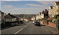
2
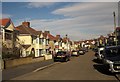
Wingfield Road, Knowle
Cars parked on pavements along this residential road. Just along here, footpath BCC/455/10 climbs to the right, but I missed it.
Image: © Derek Harper
Taken: 15 Mar 2014
0.09 miles
3
Not an easy route ahead for cyclists, Redcatch Road, Knowle, Bristol
A view from the corner of Beckington Road. On the right, a cyclist wheels his bike up the hill.
Image: © Jaggery
Taken: 11 Nov 2012
0.09 miles
4
Steep descent, Redcatch Road, Knowle, Bristol
Viewed from near the Stockwood Crescent junction. Redcatch Road descends towards St John's Lane.
Image: © Jaggery
Taken: 11 Nov 2012
0.09 miles
5
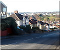
Hilly Redcatch Road, Knowle, Bristol
Houses on the north side of Redcatch Road viewed from the corner of Wingfield Road.
Image: © Jaggery
Taken: 11 Nov 2012
0.11 miles
6
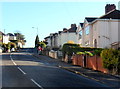
Redcatch Road, Knowle
This is the B3122, dropping steeply with good views across the city.
Image: © Derek Harper
Taken: 15 Mar 2014
0.12 miles
7
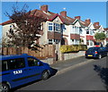
Two taxis in Ravenhill Avenue, Knowle, Bristol
Viewed from the corner of Redcatch Road.
Image: © Jaggery
Taken: 11 Nov 2012
0.12 miles
8
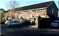
St Agnes Gardens, Knowle, Bristol
House in St Agnes Gardens viewed from St Agnes Walk.
Image: © Jaggery
Taken: 11 Nov 2012
0.13 miles
9
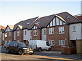
Making use of a small patch of open ground
There was a little section of Redcatch Road here that was unoccupied since the rest of the area was developed between the wars. The pressing demand to build new houses has led to the inevitable, albeit a nice modern terrace in a distinct style to contrast the existing.
Image: © Neil Owen
Taken: 20 Jan 2017
0.16 miles
10
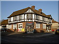
Now an Express
Previously the Friendship Inn. The mock Tudor design is from 1933 and typical of local pubs built in that period. After buying the property for about £800,000 the supermarket company have turned it into a local shop in 2009. However, they have at least kept the exterior. After all, you didn't expect Tescos to build something this stylish, did you?
Image: © Neil Owen
Taken: 1 Feb 2012
0.16 miles