IMAGES TAKEN NEAR TO
Sylvia Avenue, BRISTOL, BS3 5BZ
Introduction
This page details the photographs taken nearby to Sylvia Avenue, BS3 5BZ by members of the Geograph project.
The Geograph project started in 2005 with the aim of publishing, organising and preserving representative images for every square kilometre of Great Britain, Ireland and the Isle of Man.

There are currently over 7.5m images from over14,400 individuals and you can help contribute to the project by visiting https://www.geograph.org.uk
Image Map
Images are licensed for reuse under creativecommons.org/licenses/by-sa/2.0
Notes
- Clicking on the map will re-center to the selected point.
- The higher the marker number, the further away the image location is from the centre of the postcode.
Image Listing (85 Images Found)
Images are licensed for reuse under creativecommons.org/licenses/by-sa/2.0
Image
Details
Distance
1
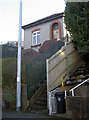
A higher power
A small electricity substation on the steep topography of Sylvia Avenue.
Image: © Neil Owen
Taken: 20 Jan 2017
0.03 miles
2
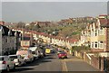
Ravenhill Road, Knowle
Terraces swoop down, and then up again towards Windmill Hill. Behind them are hillside allotments.
Image: © Derek Harper
Taken: 15 Mar 2014
0.05 miles
3
Sylvia Avenue, Bristol
Viewed from the St John's Lane end.
Image: © Jaggery
Taken: 11 Nov 2012
0.06 miles
4
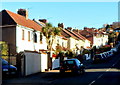
Hilly Redcatch Road, Knowle, Bristol
Houses on the north side of Redcatch Road viewed from the corner of Wingfield Road.
Image: © Jaggery
Taken: 11 Nov 2012
0.06 miles
5
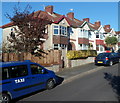
Two taxis in Ravenhill Avenue, Knowle, Bristol
Viewed from the corner of Redcatch Road.
Image: © Jaggery
Taken: 11 Nov 2012
0.07 miles
6
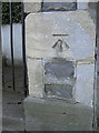
Ordnance Survey Cut Mark
This OS cut mark can be found on the wall of No75 Sylvia Avenue. It marks a point 47.454m above mean sea level.
Image: © Adrian Dust
Taken: 4 Nov 2021
0.07 miles
7
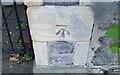
Benchmark in Sylvia Avenue
A typical scene in post-1900 Bristol would usually include some elegant stonework, with local Pennant stone. A benchmark, as listed in the Benchmark Database: http://www.bench-marks.org.uk/bm81635 , completes the scene. See Image] for a wider view of the development around Perrett's Park of over a century ago.
Image: © Neil Owen
Taken: 20 Jan 2017
0.07 miles
8
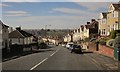
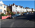
Redcatch Road, Knowle
This is the B3122, dropping steeply with good views across the city.
Image: © Derek Harper
Taken: 15 Mar 2014
0.07 miles
9
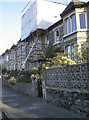
Sylvia Avenue
A view of a suburban street built over a century ago now. See Image] for a benchmark on the slightly leaning pier.
Image: © Neil Owen
Taken: 20 Jan 2017
0.08 miles
10
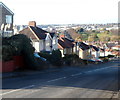
Steep descent, Redcatch Road, Knowle, Bristol
Viewed from near the Stockwood Crescent junction. Redcatch Road descends towards St John's Lane.
Image: © Jaggery
Taken: 11 Nov 2012
0.08 miles