IMAGES TAKEN NEAR TO
Malago Vale Trading Estate, St. Johns Lane, BRISTOL, BS3 5BQ
Introduction
This page details the photographs taken nearby to Malago Vale Trading Estate, St. Johns Lane, BS3 5BQ by members of the Geograph project.
The Geograph project started in 2005 with the aim of publishing, organising and preserving representative images for every square kilometre of Great Britain, Ireland and the Isle of Man.

There are currently over 7.5m images from over14,400 individuals and you can help contribute to the project by visiting https://www.geograph.org.uk
Image Map
Images are licensed for reuse under creativecommons.org/licenses/by-sa/2.0
Notes
- Clicking on the map will re-center to the selected point.
- The higher the marker number, the further away the image location is from the centre of the postcode.
Image Listing (432 Images Found)
Images are licensed for reuse under creativecommons.org/licenses/by-sa/2.0
Image
Details
Distance
1

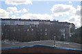
Windmill Hill Bristol
A decorative but rather complicated looking pedestrian crossing at a junction near Windmill Hill.
Image: © Robert Ashby
Taken: 24 Apr 2014
0.02 miles
3
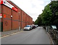
Road past the edge of Malago Vale Trading Estate, Bedminster, Bristol
VP Hire Station https://www.geograph.org.uk/photo/5919763 is on the left.
Image: © Jaggery
Taken: 5 Sep 2018
0.02 miles
4

VP Hire Station, Bedminster, Bristol
Tool hire business in Unit A, Malago Vale Industrial Estate, viewed across the B3120 St John's Lane.
Image: © Jaggery
Taken: 5 Sep 2018
0.04 miles
5
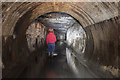
Malago storm relief drain
Before the modern Malago stormwater interceptor was built http://www.geograph.org.uk/photo/4119226 this now redundant drain transferred excess water from the Malago stream to the river Avon.
Image: © Noel Jenkins
Taken: 4 Apr 2010
0.05 miles
6
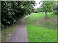
Path through a former burial ground, Bedminster, Bristol
Located near the site of the former St John's Church. This area was an extra burial place used when St John’s churchyard became full. St John's Church was severely damaged by incendiary bombs in November 1940. The church ruins were cleared away in 1967, tombs and headstones were removed and the areas grassed over.
Image: © Jaggery
Taken: 5 Sep 2018
0.05 miles
7
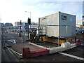
Works container in Malago Road
Major works are part of the big plan for Bedminster and the workers' think tank is planted in the middle of the road.
Image: © Neil Owen
Taken: 18 Jan 2022
0.05 miles
8
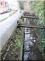
Shoring up the Malago walls
The stream runs through Bedminster and is bounded on many sides by old heavy industry sites. This area opposite the burial grounds would have been home to the Malago Vale Works, which specialised in Umber, Barytes, Ochre and Oxides. In its time the waters would have been heavily polluted, but these days is much cleaner.
Image: © Neil Owen
Taken: 18 Jan 2022
0.05 miles
9
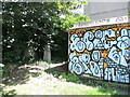
A few stones are all that are left
This is the top corner of the old St John's cemetery - a broad square of green that has a steep slope from Windmill Hill. The burial grounds have long been disused and are now largely given over to a public open space with lots of trees. However, there are a few memorial stones tucked away next to an electricity substation - which is, naturally, covered in spray.
Image: © Neil Owen
Taken: 23 Jul 2021
0.06 miles
10

Making a problem into a business opportunity
Bristol has now imposed a Clean Air Zone around much of the inner roads, leading to great debate. Meanwhile, the buses look to make capital - they have a different arrangement with the council.
Image: © Neil Owen
Taken: 7 Dec 2022
0.06 miles