IMAGES TAKEN NEAR TO
St. Johns Lane, BRISTOL, BS3 5BB
Introduction
This page details the photographs taken nearby to St. Johns Lane, BS3 5BB by members of the Geograph project.
The Geograph project started in 2005 with the aim of publishing, organising and preserving representative images for every square kilometre of Great Britain, Ireland and the Isle of Man.

There are currently over 7.5m images from over14,400 individuals and you can help contribute to the project by visiting https://www.geograph.org.uk
Image Map
Images are licensed for reuse under creativecommons.org/licenses/by-sa/2.0
Notes
- Clicking on the map will re-center to the selected point.
- The higher the marker number, the further away the image location is from the centre of the postcode.
Image Listing (125 Images Found)
Images are licensed for reuse under creativecommons.org/licenses/by-sa/2.0
Image
Details
Distance
2
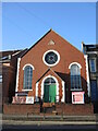
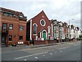
Church of Christ on St John's Lane
A small brick-built church, dated 1903, was originally an Independent Methodist church which is thought to have moved out in WWII.
Image: © Neil Owen
Taken: 22 Feb 2022
0.01 miles
3
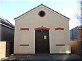
Sub-station on St John's Lane
The small electricity sub-station dates from before WWII and has a contemporary style.
Image: © Neil Owen
Taken: 22 Feb 2022
0.03 miles
5
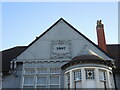
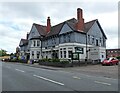
An intermediate date
The date of 1897 on what is today 'The Brunel' is somewhat misleading. The date is that of a rebuilding of the original pub, which was founded as a malthouse in the 1850s. See Image] for a wider view and more on the history of this oft-named pub.
Image: © Neil Owen
Taken: 22 Feb 2022
0.03 miles
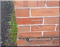
6
Ordnance Survey Cut Mark
This OS cut mark can be found on The House That Jack Built. It marks a point 12.863m above mean sea level.
Image: © Adrian Dust
Taken: 12 Mar 2020
0.04 miles
7
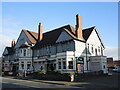
A pub by other names
The Brunel today, yesterday the House That Jack Built, the day before the Engineer's Arms...
This spot on St John's Lane has a history of serving beer. Originally a few buildings known as Napier Gardens soon had a malthouse adjoining it by the latter 1800s; beyond was a ropewalk. The Spring Head Brewery started and a George Salvidge opened a tavern in 1854, renaming the place as the Engineer's Hotel from about 1870. The name lasted four years before becoming the Engineer's Arms and the pub was rebuilt in 1897. A large expansion occurred in 1934 - see Image] - and the landlord of 1954, a George Wagstaff, renamed the pub 'The House that Jack Built'. An later landlord reverted it back to the 'Engineer's Arms' from 1976, a name that lasted until a refurbishment in 2006, whereupon the new name of 'The Brunel' was adopted.
Image: © Neil Owen
Taken: 22 Feb 2022
0.04 miles
8
Ordnance Survey Cut Mark
This OS cut mark can be found on No285 St Johns Lane. It marks a point 13.320m above mean sea level.
Image: © Adrian Dust
Taken: 12 Mar 2020
0.04 miles
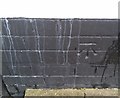
9
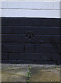
Benchmark on The Brunel
Along St John's Lane is the unmistakable pub now called The Brunel. This benchmark (as described in the Benchmark Database: http://www.bench-marks.org.uk/bm23471 ) is on the west-facing wall and has survived plenty of coats of paint. See Image] for a wider view.
Image: © Neil Owen
Taken: 29 Dec 2011
0.05 miles
10
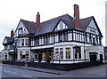
The Brunel, St John's Lane
This fine old pub was opened in 1897, but was originally half the size and named the Engineer's Arms. It was expanded to its current size in 1932 by long-serving landlord George Wagstaff, and he renamed it as The House That Jack Built in 1953. However it is now called The Brunel, presumably with a new landlord too. A benchmark can be found on the right-hand side of shot (see Image]) but the Ordnance Survey recorded it as the Jack version as it was verified in 1956.
Image: © Neil Owen
Taken: 29 Dec 2011
0.05 miles