IMAGES TAKEN NEAR TO
Berwick Lane, BRISTOL, BS35 5RU
Introduction
This page details the photographs taken nearby to Berwick Lane, BS35 5RU by members of the Geograph project.
The Geograph project started in 2005 with the aim of publishing, organising and preserving representative images for every square kilometre of Great Britain, Ireland and the Isle of Man.

There are currently over 7.5m images from over14,400 individuals and you can help contribute to the project by visiting https://www.geograph.org.uk
Image Map
Images are licensed for reuse under creativecommons.org/licenses/by-sa/2.0
Notes
- Clicking on the map will re-center to the selected point.
- The higher the marker number, the further away the image location is from the centre of the postcode.
Image Listing (84 Images Found)
Images are licensed for reuse under creativecommons.org/licenses/by-sa/2.0
Image
Details
Distance
1
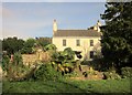
Rectory, Compton Greenfield
Originally C17 and described at http://list.english-heritage.org.uk/resultsingle.aspx?uid=1321090&searchtype=mapsearch . In the foreground, across the grass verge, flows the Lyde Brook.
Image: © Derek Harper
Taken: 22 Feb 2014
0.01 miles
2
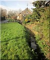
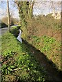
Lyde Brook
Another view similar to Image Berwick Lane carries NCN410 and is also followed by the Avon Cycleway.
Image: © Derek Harper
Taken: 22 Feb 2014
0.01 miles
3
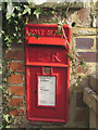
Postbox, Compton Greenfield
Elizabeth II postbox BS35 91 can also be seen in Image
Image: © Derek Harper
Taken: 22 Feb 2014
0.01 miles
4
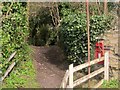
Community Forest Path at Compton Greenfield
Following footpath OAY/72 over a footbridge across the Lyde Brook and thus away from Berwick Lane. On the right is Elizabeth II postbox BS35 91.
Image: © Derek Harper
Taken: 22 Feb 2014
0.01 miles
5
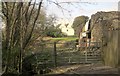
Rectory, Compton Greenfield
The C17 house is described at http://list.english-heritage.org.uk/resultsingle.aspx?uid=1321090&searchtype=mapsearch . On the right is a ruinous outbuilding at Bishop's Farm. In the foreground, the farm entrance crosses the Lyde Brook.
Image: © Derek Harper
Taken: 22 Feb 2014
0.02 miles
6
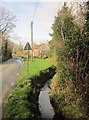
Lyde Brook
Running beside Berwick Lane, a little northwest of the scene in Image Ahead are outbuildings at The Rectory.
Image: © Derek Harper
Taken: 22 Feb 2014
0.02 miles
7
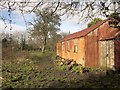
Shed, Compton Greenfield
A view of a corrugated iron hut in an old orchard, from the Community Forest Path following footpath OAY/72.
Image: © Derek Harper
Taken: 22 Feb 2014
0.03 miles
8
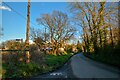
Compton Greenfield : Berwick Lane
Looking along the road.
Image: © Lewis Clarke
Taken: 14 Mar 2022
0.04 miles
9
Lyde Brook
The stream runs alongside Berwick Lane. On the right is Image] http://list.english-heritage.org.uk/resultsingle.aspx?uid=1321090&searchtype=mapsearch .
Image: © Derek Harper
Taken: 22 Feb 2014
0.04 miles
10
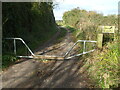
A little hop but not for wheels
A particular type of gate that allows passage for those with legs but not four wheels.
Image: © Neil Owen
Taken: 15 Oct 2020
0.06 miles