IMAGES TAKEN NEAR TO
Church Road, BRISTOL, BS35 4PW
Introduction
This page details the photographs taken nearby to Church Road, BS35 4PW by members of the Geograph project.
The Geograph project started in 2005 with the aim of publishing, organising and preserving representative images for every square kilometre of Great Britain, Ireland and the Isle of Man.

There are currently over 7.5m images from over14,400 individuals and you can help contribute to the project by visiting https://www.geograph.org.uk
Image Map
Images are licensed for reuse under creativecommons.org/licenses/by-sa/2.0
Notes
- Clicking on the map will re-center to the selected point.
- The higher the marker number, the further away the image location is from the centre of the postcode.
Image Listing (125 Images Found)
Images are licensed for reuse under creativecommons.org/licenses/by-sa/2.0
Image
Details
Distance
1
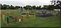
Children's play area, Severn Beach
On the east side of Ableton Lane near the village hall. https://www.geograph.org.uk/photo/5901977
Image: © Jaggery
Taken: 10 Sep 2018
0.09 miles
2
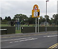
Variable speed limit sign, Ableton Lane, Severn Beach
When the lights on the sign are on, the 30mph speed limit
drops to 20mph on the approach to the village primary school. https://www.geograph.org.uk/photo/5902000
Image: © Jaggery
Taken: 10 Sep 2018
0.09 miles
3
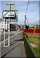
End of the 20 zone, Ableton Lane, Severn Beach
The sign is on the back of this one. https://www.geograph.org.uk/photo/5902022
Gorse Cover Road houses are in the background.
Image: © Jaggery
Taken: 10 Sep 2018
0.09 miles
4
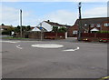
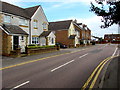
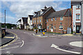
Gorse Cover Road mini-roundabout, Severn Beach
Viewed from the corner of Station Road.
Image: © Jaggery
Taken: 10 Sep 2018
0.10 miles
5
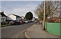
East along Station Road, Severn Beach
Towards the Gorse Cover Road/Ableton Lane junction. The broken white lines
on the right are at the Stride Close junction which is opposite the Salmon Close junction.
Image: © Jaggery
Taken: 10 Sep 2018
0.10 miles
7
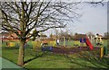
Severn Beach : Playground
A playground beside Ableton Lane in Severn Beach.
Image: © Lewis Clarke
Taken: 8 Mar 2014
0.10 miles
8
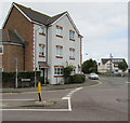
Three-storey housing on a Severn Beach corner
On the corner of Station Road and Gorse Cover Road.
Image: © Jaggery
Taken: 10 Sep 2018
0.10 miles
9
Severn Beach : Ableton Lane
A road heading through the village of Severn Beach in South Gloucestershire.
Image: © Lewis Clarke
Taken: 8 Mar 2014
0.11 miles
10
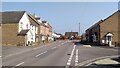
Station Road, Severn Beach
Station Road connects Ableton Lane with the village centre, passing (as the name indicates) the railway station.
Image: © Stephen McKay
Taken: 1 Aug 2023
0.11 miles