IMAGES TAKEN NEAR TO
Abbott Road, BRISTOL, BS35 4PU
Introduction
This page details the photographs taken nearby to Abbott Road, BS35 4PU by members of the Geograph project.
The Geograph project started in 2005 with the aim of publishing, organising and preserving representative images for every square kilometre of Great Britain, Ireland and the Isle of Man.

There are currently over 7.5m images from over14,400 individuals and you can help contribute to the project by visiting https://www.geograph.org.uk
Image Map (Loading...)


Getting Data...Please wait
Leaflet Map data © OpenStreetMap
Images are licensed for reuse under creativecommons.org/licenses/by-sa/2.0
Notes
- Clicking on the map will re-center to the selected point.
- The higher the marker number, the further away the image location is from the centre of the postcode.
Image Listing (52 Images Found)
Images are licensed for reuse under creativecommons.org/licenses/by-sa/2.0
Image
Details
Distance
1
Abbott Road, Severn Beach
Cul-de-sac on the east side of Ableton Lane.
Image: © Jaggery
Taken: 10 Sep 2018
0.02 miles
2
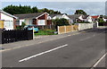
Severnwood Gardens bungalows, Severn Beach
Viewed from the corner of Ableton Lane at the southern edge of the village.
Image: © Jaggery
Taken: 10 Sep 2018
0.05 miles
3
Corner of Abbott Road and Ableton Lane, Severn Beach
Viewed across Ableton Lane.
Image: © Jaggery
Taken: 10 Sep 2018
0.06 miles
4

Severnwood Gardens, Severn Beach
Cul-de-sac on the east side of Ableton Lane near the A403 Severn Road junction.
Image: © Jaggery
Taken: 10 Sep 2018
0.06 miles
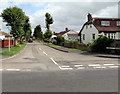
5
Into the village of Severn Beach, South Gloucestershire
Viewed from the corner of Severnwood Gardens looking along Ableton Lane.
The Severn Beach boundary sign https://www.geograph.org.uk/photo/5902105 is on the left.
Image: © Jaggery
Taken: 10 Sep 2018
0.07 miles
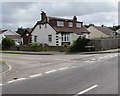
6
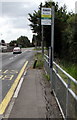
Severnwood Gardens bus stop, Severn Beach
The stop is on Ableton Lane. The car is passing the Severnwood Gardens junction. In September 2018, this stop is on bus route 623 to Cribbs Causeway & Bristol Bus Station and also on bus route 625 to Frenchay & Frenchay Campus via Easter Compton, Cribbs Causeway, Patchway, Little Stoke and Bristol Parkway railway station.
Image: © Jaggery
Taken: 10 Sep 2018
0.07 miles
7
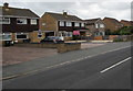
Ableton Lane houses, Severn Beach
This part of Ableton Lane is between Denny Isle Drive and Abbott Road.
Image: © Jaggery
Taken: 10 Sep 2018
0.08 miles
8
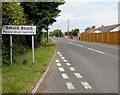
Southern boundary sign, Severn Beach, South Gloucestershire
Alongside Ableton Lane 80 metres north of the A403 Severn Road junction.
Image: © Jaggery
Taken: 10 Sep 2018
0.09 miles
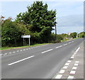
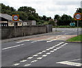
9
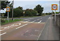
Start of the 30 zone on Ableton Lane south of Severn Beach
The Ableton Lane speed limit drops from 50mph to 30mph 40 metres north of the A403 Severn Road junction.
The Severn Beach village boundary sign https://www.geograph.org.uk/photo/5902105 is in the background on the left.
Image: © Jaggery
Taken: 10 Sep 2018
0.10 miles
10
End of the 30 zone, Ableton Lane, Severn Beach
Beyond the southern edge of the village, on the approach to the A403 junction, the 30mph speed limit increases to 50mph.
Image: © Jaggery
Taken: 10 Sep 2018
0.10 miles