IMAGES TAKEN NEAR TO
Gorse Cover Road, BRISTOL, BS35 4NT
Introduction
This page details the photographs taken nearby to Gorse Cover Road, BS35 4NT by members of the Geograph project.
The Geograph project started in 2005 with the aim of publishing, organising and preserving representative images for every square kilometre of Great Britain, Ireland and the Isle of Man.

There are currently over 7.5m images from over14,400 individuals and you can help contribute to the project by visiting https://www.geograph.org.uk
Image Map (Loading...)


Getting Data...Please wait
Leaflet Map data © OpenStreetMap
Images are licensed for reuse under creativecommons.org/licenses/by-sa/2.0
Notes
- Clicking on the map will re-center to the selected point.
- The higher the marker number, the further away the image location is from the centre of the postcode.
Image Listing (180 Images Found)
Images are licensed for reuse under creativecommons.org/licenses/by-sa/2.0
Image
Details
Distance
1
Salmon Close, Severn Beach
Cul-de-sac on the north side of Station Road.
Image: © Jaggery
Taken: 13 Sep 2018
0.06 miles
2
Salmon Close in Severn Beach
Short cul-de-sac on the north side of Station Road.
Image: © Jaggery
Taken: 10 Sep 2018
0.06 miles
3
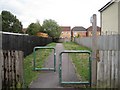
Path from Beach Avenue to Gorse Cover Road, Severn Beach
Pointing ahead, a public footpath sign is near the camera in Beach Avenue.
Image: © Jaggery
Taken: 13 Sep 2018
0.06 miles
4
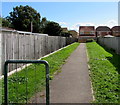
Footpath to Gorse Cover Road
Looking southeast from Beach Avenue.
Image: © Robin Stott
Taken: 16 Jul 2011
0.07 miles


7
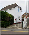
Crossing Cottage, Station Road, Severn Beach
Black silhouettes of railway locomotives are on the entrance gates to Crossing Cottage. This house was the former residence of the crossing keeper who manned the gates of Station Road level crossing in the era when the railway (which now ends at nearby Severn Beach station) continued to the Great Western Railway main line at Pilning. The level crossing no longer exists. Severn Beach Heritage Trail marker number 10 (for Crossing Cottage) is on the lamppost on the right below the Station Road name sign.
Image: © Jaggery
Taken: 10 Sep 2018
0.08 miles
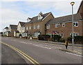
8
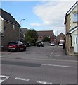
Three-storey housing on a Severn Beach corner
On the corner of Station Road and Gorse Cover Road.
Image: © Jaggery
Taken: 10 Sep 2018
0.08 miles
9
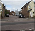
Eastern end of Station Road, Severn Beach
Houses on the north side of Station Road between Gorse Cover Road and Salmon Close.
Image: © Jaggery
Taken: 10 Sep 2018
0.09 miles
10
Down's Bakery, Severn Beach
At 105 Beach Road.
Image: © Jaggery
Taken: 10 Sep 2018
0.09 miles