IMAGES TAKEN NEAR TO
Redwick Road, BRISTOL, BS35 4LQ
Introduction
This page details the photographs taken nearby to Redwick Road, BS35 4LQ by members of the Geograph project.
The Geograph project started in 2005 with the aim of publishing, organising and preserving representative images for every square kilometre of Great Britain, Ireland and the Isle of Man.

There are currently over 7.5m images from over14,400 individuals and you can help contribute to the project by visiting https://www.geograph.org.uk
Image Map
Images are licensed for reuse under creativecommons.org/licenses/by-sa/2.0
Notes
- Clicking on the map will re-center to the selected point.
- The higher the marker number, the further away the image location is from the centre of the postcode.
Image Listing (33 Images Found)
Images are licensed for reuse under creativecommons.org/licenses/by-sa/2.0
Image
Details
Distance
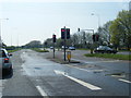
1
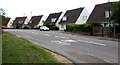
Low-pitched roofs, Redwick Road, Pilning
Houses viewed across the B4064 Redwick Road from the corner of Vicarage Road.
Image: © Jaggery
Taken: 13 Sep 2018
0.03 miles
2
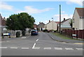
Vicarage Road, Pilning, South Gloucestershire
From the B4064 Redwick Road, Vicarage Road leads to Keen's Grove and Chessell Avenue.
Image: © Jaggery
Taken: 13 Sep 2018
0.04 miles
3
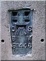
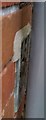
Ordnance Survey Flush Bracket (S1448)
This OS Flush Bracket can be found on the Mafeking Hall. It marks a point 6.832m above mean sea level.
Image: © Adrian Dust
Taken: 16 Jan 2020
0.04 miles
4
Vicarage Road telecoms cabinets, Pilning, South Gloucestershire
The two dark green cabinets are on the left here https://www.geograph.org.uk/photo/5904457 near the corner of the B4064 Redwick Road.
Image: © Jaggery
Taken: 13 Sep 2018
0.04 miles
5
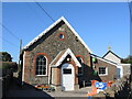
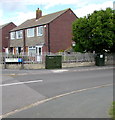
The Mafeking Hall
A former mission hall of 1881, it is now owned by the Scouts' movement and is the home of the 1st Severn Beach Scout Group. After a major refurbishment in 2013, the hall is also open to various non-scouting groups, including the Women’s Institute and church coffee mornings.
Image: © Neil Owen
Taken: 23 Jun 2024
0.04 miles
6
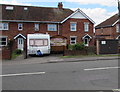
Redwick Road Pumping Station, Pilning, South Gloucestershire
The Wessex Water identifier on the brick & metal structure on the right is
15180 REDWICK ROAD, PILNING PUMPING STATION.
Image: © Jaggery
Taken: 13 Sep 2018
0.05 miles
7
Ordnance Survey Flush Bracket (S1449)
This OS Flush Bracket can be found on No63 Redwick Road. It marks a point 6.723m above mean sea level.
Image: © Adrian Dust
Taken: 16 Jan 2020
0.07 miles
10
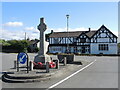
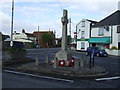
The memorial at the Cross Hands junction
Pilning's war memorial has been on a journey. Originally installed here at the junction of the B4064 and Northwick Road after WWI, it stood on a narrower road and suffered from problems in WWII. In 1943 a bombing raid caused some damage to the inn and the memorial, both being repaired. Ironically, the following year an American Army vehicle hit it and caused more damage. It was repaired again but was relocated elsewhere. By 1979, calls to return it here at the original place grew, but the means to do so were unforthcoming. With passing years the effort finally brought about the reinstatement in 1994. Grade II listed.
Sadly, although the memorial is now in better condition, the Cross Hands Inn opposite now faces an uncertain future.
Image: © Neil Owen
Taken: 23 Jun 2024
0.13 miles