IMAGES TAKEN NEAR TO
Northwick Road, BRISTOL, BS35 4JE
Introduction
This page details the photographs taken nearby to Northwick Road, BS35 4JE by members of the Geograph project.
The Geograph project started in 2005 with the aim of publishing, organising and preserving representative images for every square kilometre of Great Britain, Ireland and the Isle of Man.

There are currently over 7.5m images from over14,400 individuals and you can help contribute to the project by visiting https://www.geograph.org.uk
Image Map
Images are licensed for reuse under creativecommons.org/licenses/by-sa/2.0
Notes
- Clicking on the map will re-center to the selected point.
- The higher the marker number, the further away the image location is from the centre of the postcode.
Image Listing (35 Images Found)
Images are licensed for reuse under creativecommons.org/licenses/by-sa/2.0
Image
Details
Distance
1
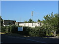
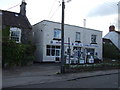
Pilning telephone exchange
The exchange is a post-war development around Wain Bridge, but it looks pretty derelict now. Perhaps one or two things are still in use, as suggested by the mast. Behind it is the new surgery.
Pilning's first exchange was a manual switchboard operating from the Post Office, opening on 25th February, 1929. That was replaced by the exchange seen here on 28th March, 1973, and at a cost of £78,000. That system was replaced in 2010.
Image: © Neil Owen
Taken: 23 Jun 2024
0.03 miles
2
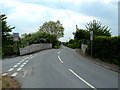
Bridge over dismantled railway at Pilning, Gloucestershire
Image: © Anthony O'Neil
Taken: 1 May 2011
0.04 miles
3
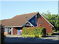
Pilning Community Pharmacy
A new facility for the village, located behind the telephone exchange.
Image: © Neil Owen
Taken: 23 Jun 2024
0.05 miles
4
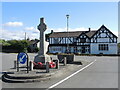
The memorial at the Cross Hands junction
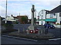
Pilning's war memorial has been on a journey. Originally installed here at the junction of the B4064 and Northwick Road after WWI, it stood on a narrower road and suffered from problems in WWII. In 1943 a bombing raid caused some damage to the inn and the memorial, both being repaired. Ironically, the following year an American Army vehicle hit it and caused more damage. It was repaired again but was relocated elsewhere. By 1979, calls to return it here at the original place grew, but the means to do so were unforthcoming. With passing years the effort finally brought about the reinstatement in 1994. Grade II listed.
Sadly, although the memorial is now in better condition, the Cross Hands Inn opposite now faces an uncertain future.
Image: © Neil Owen
Taken: 23 Jun 2024
0.06 miles
5
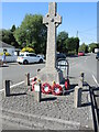
Pilning war memorial
The memorial to Pilning's fallen in both world wars is a granite base, shaft and wheel cross. As an up-to-date feature, there is a QR code panel for greater illumination. Grade II listed.
Image: © Neil Owen
Taken: 23 Jun 2024
0.06 miles
7
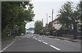
Cross Hands Road in Pilning
Looking westwards towards the centre of the village.
Image: © Ruth Riddle
Taken: 13 Jun 2012
0.06 miles
8
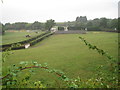
Cross Hands Halt railway station (site), South Gloucestershire
Opened in 1928 by the Great Western Railway on the loop line from Bristol via Pilning to Severn Beach and back to Bristol, this station closed in 1964. It is hard to believe that there was ever a railway here, but before the opening of the Severn Tunnel, this was also the 'main' line to South Wales via the New Passage ferry. View north west towards New Passage and Severn Beach.
Image: © Nigel Thompson
Taken: 9 Sep 2013
0.07 miles
10
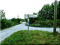
Road junction near Pilning, Gloucestershire
Image: © Anthony O'Neil
Taken: 1 May 2011
0.08 miles