IMAGES TAKEN NEAR TO
Pilning Street, BRISTOL, BS35 4HN
Introduction
This page details the photographs taken nearby to Pilning Street, BS35 4HN by members of the Geograph project.
The Geograph project started in 2005 with the aim of publishing, organising and preserving representative images for every square kilometre of Great Britain, Ireland and the Isle of Man.

There are currently over 7.5m images from over14,400 individuals and you can help contribute to the project by visiting https://www.geograph.org.uk
Image Map
Images are licensed for reuse under creativecommons.org/licenses/by-sa/2.0
Notes
- Clicking on the map will re-center to the selected point.
- The higher the marker number, the further away the image location is from the centre of the postcode.
Image Listing (8 Images Found)
Images are licensed for reuse under creativecommons.org/licenses/by-sa/2.0
Image
Details
Distance
1
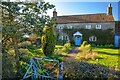
Awkley : Orchard Farm
Orchard Farm in Awkley.
Image: © Lewis Clarke
Taken: 14 Mar 2022
0.01 miles
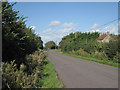
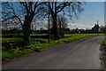
2
Awkley : Pilning Street
Looking along the road.
Image: © Lewis Clarke
Taken: 14 Mar 2022
0.03 miles
3
Awkley : Laurel Farm
Looking towards Laurel Farm off Pilning Street.
Image: © Lewis Clarke
Taken: 14 Mar 2022
0.05 miles
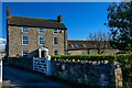
4
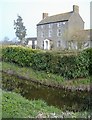
Laurel Farm
The drainage channel in the foreground, is the Gumburn Rhine.
Image: © Roger Cornfoot
Taken: 28 Mar 2007
0.06 miles
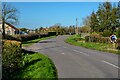
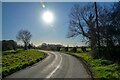
5
Awkley : Pilning Street
Looking along the road.
Image: © Lewis Clarke
Taken: 14 Mar 2022
0.13 miles
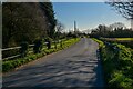
6
Awkley : Pilning Street
Looking along the road.
Image: © Lewis Clarke
Taken: 14 Mar 2022
0.15 miles
7
Awkley : Pilning Street
Looking along Pilning Street.
Image: © Lewis Clarke
Taken: 14 Mar 2022
0.23 miles